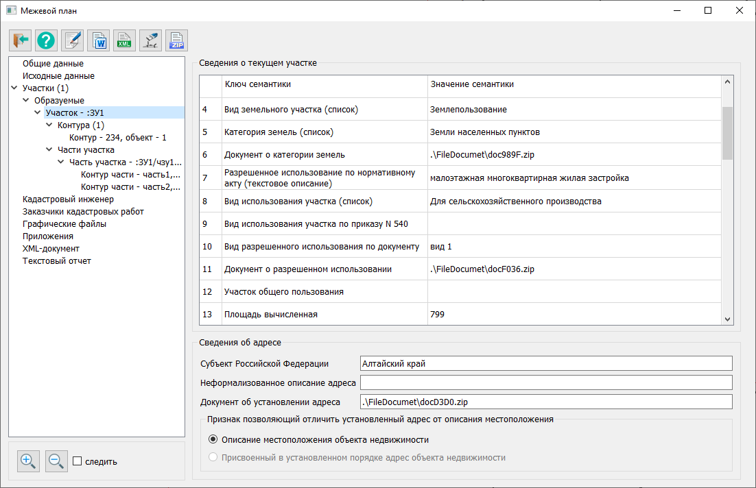
Land survey plan dialog |


|
|
To correctly initialize the "Land Survey Plan" dialog with information from the map, a specific sequence of actions must be followed according to one of the options:
Option 1. Formation or clarification of the boundaries of a single-contour land plot: — Click the mode button; — Indicate the cadastral work object on the map. Option 2. Formation or clarification of a multi-contour land plot: — Click the mode button; — Indicate one of the objects included in the set — the multi-contour land plot — on the map. Option 3. Formation or clarification of several land plots: — Highlight all formed or clarified plots on the map; — Click the mode button. Option 4. Formation or clarification of part(s) of a land plot: — Click the mode button; — Select an existing plot on the map within which the processed parts of the plot are indicated.
Attention! If it is necessary to include a multi-contour object in the selection, the main object of the set must be highlighted on the map.
For the selected or highlighted objects on the map, the program automatically determines the composition of cadastral objects, including: — Land plots; — Contours of land plots (for a single-contour plot — one contour; for a multi-contour or unified land use – several contours combined into a set of objects); — Contours of adjacent clarified land plots; — Parts of land plots.
During processing, information about the composition of data sets, geometry of map objects, spatial relationships between objects, and identification semantics is used, including: — Cadastral number (KADNUM); — Accounting number (PART_NUMB); — Designation (MARKING); — Part number of the object (PART_NUMB1).
The "Land Survey Plan" dialog is displayed, where the left side shows a tree of information nodes, and the right side displays frames for viewing and editing information corresponding to the node selected in the tree.
For all nodes except the "Plots" node, the information is obtained from the cadastral work database. The fields in the dialog are populated with data from the Cadastral Work Database in accordance with the contract associated with the selected object. If no contract is linked to the selected plot, the user will be prompted to create a new contract or link an existing one. For multiple objects highlighted on the map, the contract of the first object is analyzed.
On the toolbar of the Land Survey Plan dialog, the following buttons are located:
On the bottom panel, the following buttons are located:
If the "Track" checkbox is checked, when selecting an object in the "Plots" node, the selected object will be marked on the map. When the Land Survey Plan dialog is called, a connection to the cadastral work database is established. Based on the map name and object number in the cadastral work database table, a search for the relevant contract is performed. If no contract is found, the Add New Contract dialog is invoked. After entering information about the new contract, details about the selected object are recorded in the map name and object number fields.
To initialize the dialog, the semantics of the map object and attribute values are read from the cadastral work database to populate the nodes: Client ordering cadastral work
The composition of information nodes is formed taking into account the structure of the electronic XML document. When clicking on a node in the information tree, the following actions are performed: — identification of the node name and identification information; — display of the required frame in the right part of the dialog. |

