Land survey plan. Graphic files |


|
|
When selecting the Graphic Files node in the data tree, a request is made to the Base of cadastral works, searching for identification information about the node and filling in the frame elements.
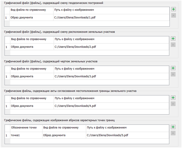
The Graphic Files dialog window includes the following tables: — Graphic file(s) containing the scheme of geodetic constructions; — Graphic file(s) containing the layout of land plots; — Graphic file(s) containing drawings of land plots; — Graphic files containing acts of agreement on the location of land plot boundaries; — Graphic files containing images of outlines of characteristic points.
To the right of each table, there is a panel with a set of buttons that control the composition of the table rows: add and remove. To add a new graphic file, you need to click the Add The Remove
The information specified in the elements of the dialog window "Land survey Plan" for the "Graphic Files" node is used when filling out sections of the electronic XML document and is included in the ZIP archive for submission to the State Register of Real Estate (EGRN). PDF files can be used as data for the graphic part.
The "Graphic File(s)" element, which contains a drawing of the land plot, is mandatory for completion.
The "Graphic File(s)" containing the scheme of geodetic constructions is used to fill out the report (section Scheme of geodetic constructions) of the XML document (element SchemeGeodesicPlotting). The "Graphic File(s)" containing the layout of land plots is used to fill out the report (section Scheme of land plot locations) of the XML document (element SchemeDisposition). The "Graphic File(s)" containing drawings of land plots is used to fill out the report (section Drawing of land plots and their parts) of the XML document (element DiagramParcelsSubParcels). The information from the list of "Graphic Files" containing acts of agreement on the location of land plot boundaries is used in the XML document (element AgreementDocument). The graphic files containing images of outlines of characteristic points are used to fill out the report (section Coordinates of boundary points of land plots) of the XML document (element SchemeDisposition).
The section Coordinates of boundary points of land plots is included in the cadastral plan, provided that the boundaries of the land plots contain characteristic points that are common to the boundaries of three or more land plots, within a radius of 40 meters from which there are at least three long-term, clearly recognizable objects in the terrain (for example, structural elements of buildings, structures, or utility poles). If such objects are not present in the terrain, the section Coordinates of boundary points of land plots will not be included in the cadastral plan. |