Land survey plan. Land plots

Print Previous page Top page Next page

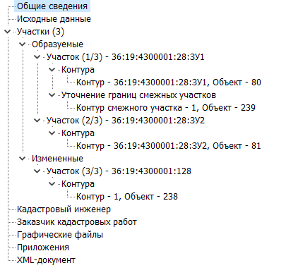
The "Plots" node has a hierarchical structure based on the type and mutual arrangement of the cadastral objects specified in the table.


To include a land plot in a specific node, the program uses its key:

— NEWLAND — contours of the formed plot or the formed contour of the clarified multi-contour plot;

— MODLAND — contours of the modified plot;

— ADJLAND — clarified contours of the clarified plot;

— INLAND — original contours of the clarified plot.


The program analyzes the type of object and includes information about it in nested nodes within the "Plots" node, taking into account the type:

— Formed;

— Clarified;

— Modified.

33


The number of nodes "Plot" in the "Formed" node equals the number of formed plots.  

The number of nodes "Plot" in the "Clarified" node equals the number of clarified plots.  

The number of nodes "Plot" in the "Modified" node equals the number of modified plots.


Inside the "Plot" node, information about the external boundaries of the plot is displayed:  

— Node "Contours" — external boundaries of the current plot;  

— Node "Clarification of Boundaries of Adjacent Plots" — boundaries of adjacent land plots for the current plot.


When selecting the nodes "Plots," "Formed," "Modified," and "Clarified," a blank page is displayed on the right side of the dialog.


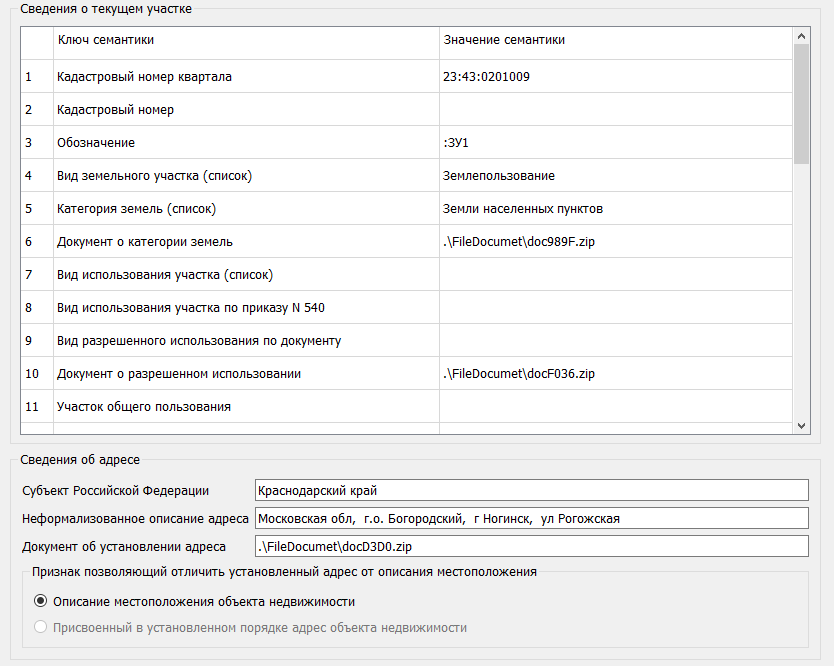
When selecting the node "Plot" or "Contour" in the data tree, a request is made to the map to retrieve the semantic values of the corresponding cadastral object and fill in the elements of the frame.


32


The list of semantics for the land plot displayed when selecting the node 'Plots' is provided in the table. For multi-contour objects, the semantics of the main object of the set are used


Name of the semantics

Key of the semantics

Purpose

The object is located in the block with the cadastral number

KADNUM_K

Cadastral block number where the land plot is fully located - CadastralBlock.

Cadastral number of the plot

KADNUM

Cadastral number of the plot in the Unified State Register of Real Estate (EGRN) - CadastralNumber.

Designation

MARKING

Designation of the new land plot - Definition.

Type of land plot

PARCELS

Defines the type of plot: ordinary land plot, multi-contour land plot, unified land use.

Land category

ASSIGNME

Land category - Category.

Document on land category

DOC_ASSIGNME

Details of the document confirming information about the land category - DocCategory.

Permitted use according to regulatory act (text description)

PERMIT_USE_TEXT

Type of permitted use of the land plot based on other documents established by the legislation of the Russian Federation.

Permitted use of the plot

PURPOSE

The type of permitted use of the land plot

Use of the plot according to Order 540

ALLOWED_USE

According to the classifier of types of permitted land use, dAllowedUse - LandUse

Use of the plot according to the document

EXTRA

Type of permitted use of the land plot - ByDocument.

Document on permitted use

DOC_PURPOSE

Details of the document establishing the type of permitted use of the land plot - DocLandUse.

Public use plot

Common

Sign of a public use plot.

Area according to the map


Area of the land plot - Area.

Area according to the document

AREADOC

Площадь земельного участка по сведениям ЕГРН - AreaInGKN

Initial plots (list)

KN_SOURSE

Кадастровые номера земельных участков, из которых образован данный участок - PrevCadastralNumbers

Access provision (list)

ACCESS

Сведения об обеспечении доступа (прохода или проезда от земель общего пользования, земельных участков общего пользования, территории общего пользования) - ProvidingPassCadastralNumbers

Buildings and structures (list)

BUILDS

Сведения об объектах недвижимости, расположенных  на образуемом земельном участке - ObjectsRealty

Method of formation

FORMATION2

Способ образования земельного участка - Method

Information on plot formation


AdditionalFormation

Дополнительные сведения об образовании земельного участка путем перераспределения - AdditionalFormation

Minimum size

AREAMIN

Предельный минимальный  размер земельного участка - MinArea

Maximum size

AREAMAX

Предельный максимальный размер земельного участка - MaxArea

Type of natural object

NaturalObjName

Вид объекта - Kind

Purpose of forests

ForestUse

Целевое назначение (категория) лесов - ForestUse

Category of protective forests

FOREST_CATEGORY

Категория защитных лесов - CodeProtectiveForest

Name of the forestry

NAME_LES

Наименование лесничества, участкового лесничества - Forestry

Numbers of forest quarters (list)

KV

Номера лесных кварталов - QuarterNumbers

Designation of the territorial zone

NameZone

Индивидуальное обозначение (вид, тип, номер, индекс) территориальной зоны - TerritorialZone

Registry number of the territorial zone


NumberZone

Реестровый номер границы - RegNumbBorde

Numbers of plots excluded from the EGP

REMOVE

Исключаемые из состава ЕЗ входящие участки - DeleteEntryParcels

Other information

OVERLOAD

Указываются сведения о содержании ограничения права, обременения земельного участка, если такое ограничение (обременение)установлено или устанавливается в отношении всего земельного участка - Note

Information on the land surveying project

NominalNumber

Условный номер земельного участка - NominalNumber

Information on the zone or territory

RegNumbBorder

Реестровый номер границы - RegNumbBorder


The list of semantics for the external contour of a multi-contour land plot or unified land use, displayed when selecting the "Contour" node, is presented in the table.


Name of the semantics

Key of the semantics

Purpose

The object is located in the block with the cadastral number

KADNUM_K

Number of the cadastral district where the land plot is fully located

Cadastral number

KADNUM

Cadastral number

Account number

PART_NUMB

Account (serial) number of the boundary

Area according to the map  


Area of the land plot - Area

Area according to the document

AREADOC

Area of the land plot according to EGRN data - AreaInGKN

Method of determining coordinates (list)

METHOD

Method of determining coordinates (list)

Coordinate system of the point's position  

MT

Value of SCP used in calculating the area determination error

Description of the boundary passage  

BORDER

Description of the boundary passage

Formula for calculating Mt  

FORMULA

Formula for calculating Mt

Formula for calculating the area  

FORMULA_S

Formula for calculating the area


The list of semantics displayed when selecting the node "Contour of the part" is presented in the table.


Name of the semantics

Key of the semantics

Purpose

Cadastral number


KADNUM

Cadastral number

Designation


MARKING

Designation of the new land plot - Definition

Area according to the map


Area of the land plot - Area

Area according to the document


AREADOC

Area of the land plot according to the data from the Unified State Register of Real Estate (EGRN) AreaInGKN

Other information

OVERLOAD


Information on the content of rights restrictions or encumbrances on the land plot, if such restrictions (encumbrances) are established or being established in relation to the entire land plot - Note

Characteristics of the part


CHARACTER

Characteristics of the part

Method of determining coordinates (list)


METHOD

Method of determining coordinates (list)

Description of boundary passage


BORDER

Description of boundary passage

СКП положения точки

SCP position of the point


MT

Value of SCP used in calculating the error of area determination

Formula for calculating Mt


FORMULA

Formula for calculating Mt


Formula for calculating area

FORMULA_S

Formula for calculating area


The list of semantics displayed when selecting the "Contour" node is provided in the table. Editing of the elements is not available. 

To edit, it is necessary to invoke the corresponding dialog using the Edit Cadastral Work Object Semantics button 31.