Setting parameters for searching or displaying map objects

Print Previous page Top page Next page

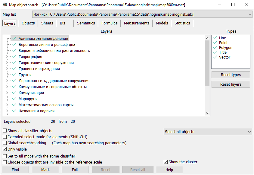
ic_8020 The dialogs «Map object search» and «Map contents» are intended for setting conditions of search/mark of vector map objects and changing the composition of displayed objects, respectively.


mapselec_POISKdlg_engl


Main tabs

Layers

Selection of layers, map classes and localization of objects

Objects

Selection of objects view included into the selected layers, classes and localizations on the «Layers» tab

Sheets

Selection of nomenclature sheets of a multisheet map

IDs

Selection of objects by a range of unique identifiers

Semantics

Selection of objects by a combination of conditions over the values of semantic characteristics

Formulas

Selection of objects based on a list of mathematical formulas and a range of values

Measurements

Selection of objects according to their spatial characteristics

Models

Saving all conditions for selecting objects

Statistics

Displaying information about the presence of rules for selecting objects on different tabs


Additional settings

Show all classifier objects

Displaying the full composition of the classifier on the «Layers» and «Objects» tabs

Set for all maps with the same classifier

Duplicating the conditions for selecting objects specified for the current map to all maps with the same RSC classifier

Select all objects/Select draw objects only/Do not select draw objects

Setting conditions for selection of graphic objects

Choose objects that are invisible at the reference scale

Disabling the display of objects whose visibility limits do not include the base scale of the map

Show the cluster

Enabling generalization of point symbols, for which the display of clusters is customized in the classifier


The «Map Contents» dialog allows you to set the composition of displayed objects and close the dialog by clicking the «Set up» button or to change composition without closing the dialog by clicking the «Apply» button.


In the «Map object search» dialog box, you can additionally set:

- Only visible - perform a search of objects taking into account the specified display conditions (intersection of the conditions of search and display);

- Global search/marking - perform search and marking on all maps of the document;

- Choose objects that are invisible at the reference scale - do not select objects whose visibility limits include the base map scale (used when setting up multiscale maps that change the composition of displayed objects when scaling).


The «Map object search» dialog allows you to iterate over objects one by one if you press the «Find» button, or to mark all objects at once according to specified conditions if you press the «Mark» button.


To clear the search or display conditions in all bookmarks and for all maps, use the «Reset all» button.

To clear the search or display conditions in all bookmarks and for the current map, use the «Reset» button.