Control Modes |


|
|
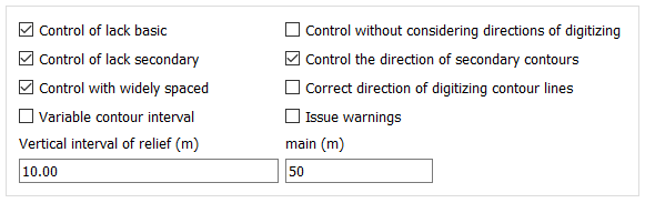
Control modes allow adjusting the verification of relief objects depending on the object composition of the work area.
Control with widely spaced — allows accounting for the presence of sparse contour lines on the map. This mode is used to reduce error messages when contour line spacing is present on the sheet being checked. Control the directions of secondary contours — for checking the digitization direction of supplementary contour lines. If not specified, supplementary contour lines are checked only by elevation. Control without considering directions of digitizing — to reduce error messages when the rule for setting the digitization direction of contour lines is not followed.
In case the control protocol issues a message about Digitization Direction Mismatch, the following map object corrections are possible: — change the digitization direction of the contour line; — change the value of the erroneous elevation of one of the objects; — add missing contour lines to the map, for example: around the corresponding point objects.
Variable contour interval — for controlling absolute elevations of a topographic map with variable contour intervals. Issue warnings — this mode is disabled by default. Disabling this mode reduces the number of program messages, which facilitates analysis of control results.
|