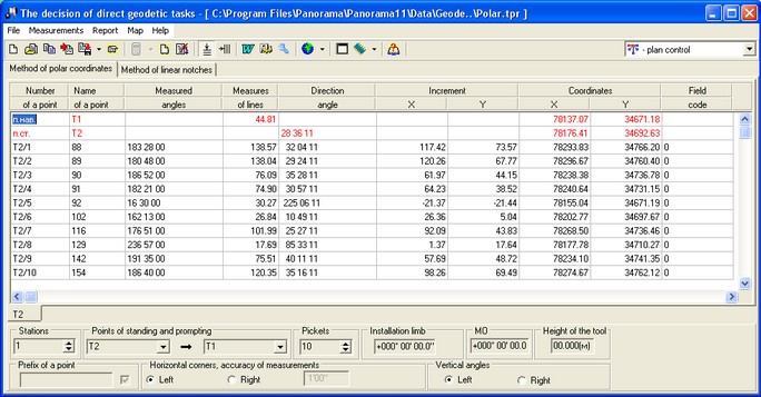
Method of polar coordinates |


|
|
By the given method the coordinates of a picket point are defined on the ray dropped from initial point under some angle from basis of construction and on the distance specified from initial point (a point of standing).
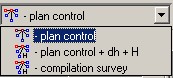
The program allows to define both plan position of a point, and high-altitude. The kind of survey is selected from the drop-down list which is located in the right top corner of a dialog box.
In view of the chosen kind of survey the fields of the table for data input are opened/closed. At according to compilation survey it is necessary to set «Type of used device» (Measurement / Measurement of measures of lines) It is very important at calculation of horizontal distance. Recommended sequence of operations execution: Choose from the drop-down list (the list of points of a course) necessary to you the points of standing and promptings. Thus, two obligatory lines of the table will automatically be filled. Coordinates and heights marks of points of standing and prompting are selected from the corresponding columns of the task «Construction of a theodolitic course» or the result of the solution of a direct geodetic task is taken. If you wish to fill these two lines with data which did not be calculated in the task «Construction of a theodolitic course» then names of these points can be entered manually and to choose (to click on other any component, any line of the table). Then to fill with data these lines: Obligatory parameters: - Coordinates of a point of standing; - Coordinates of a point of prompting or a direction angle of zero of a theodolite; (If the direction angle of initial (starting) directions in a direct geodetic task is defined from a point of standing, i.e. for the device focused onto the north he is equal 0 degrees then data on this angle are entered into the first line " п.нав. ", otherwise, if the direction angle is defined onto a point of standing, i.e. for the device focused onto the north is equal 180 degrees then this angle is entered into the second line " п.ст. ".)
Position in a horizontal plane of a surveyed point of district concerning a basic line is defined by measurement of a horizontal angle and distance D by which then its horizontal projection d is calculated.
Having set Quantity of pickets, into line onto each picket you must enter: - horizontal corner; - measured horizontal corner at calculations is corrected (decreases) onto size of installation of a limb which is entered into a corresponding window; - vertical angle (right or left); - measured distance or a horizontal distance into corresponding columns.
At calculation of the horizontal distance, data are taken from columns “D(m)-measured distance” and “AngleVer”. At absence of one of parameters, it is supposed, that the horizontal distance to calculate is not necessary and it is entered into a column “d (m)-horizontal distance”, differently a horizontal distance each time is recalculated. If into a column DeltaH (height difference or excess) height differences have been entered manually (as initial data) they will not be recalculated. They will not be recalculated and by repeated pressing the Calculate button, if have remained in this column after the previous calculations. For repeated calculations it is necessary to clear a corresponding column. To enter the source data into the table or manually ( example ), or from earlier created file of source data (Open item in the File menu or Open toolbar button). Thus, if the theodolitic (tacheometric) course has been constructed preliminarily then at coincidence of the name of the entered point with any point of a course its coordinate will be entered into the table automatically. If necessary entered data may be corrected (it is important: upon termination of correction of the table cell it is necessary to press Enter). Also source data it is possible to receive and enter, using library “GeoLoad.dll” (Import item in File menu or the Import toolbar button). After data have been entered, carry out calculations on the given point of standing (Calculate item in Measurement menu). Calculations make by formulas: For data input for other point of standing it is necessary to pass to a bookmark of this point of standing (if it is present). If the bookmark is not created yet to create it, it is necessary to increase quantity of stations and to pass to the necessary station, (having clicked on heading of the bookmark of corresponding station). Actual change of data in cells occurs only after new record is chosen (moving by arrows, tabulation, click by the mouse, etc.) At erroneous input of source data all window can be cleaned (Clear the data of current calculation sheet toolbar button or the similar item in Measurements menu) and to enter new data. After input of the source data it is possible to save them in a file of a format *.tpr for their repeated use in the further (Save item in the File menu or the Save toolbar button). The received results can be saved in the form of the calculated sheet. Thus results of calculations can be seen at first in «Word», and in the further this sheet can be saved or printed out by means of Word. For creation of such sheet it is necessary, that there was a Template for report. The choice of a pattern is carried out in dialogue «the Report on measurements by a method of polar coordinates» It is possible to put onto user map the received points (Map menu or To plot objects toolbar button). Those pickets which have own name (in a column the Name) are put onto a map. The report sheet according to data of a direct task is created both onto one, and onto all stations at once. Coordinates and names of the received points will be stored in memory up to the closing the basic dialog box "Execution of geodesy calculations" and can be used in tasks: Return geodetic task and Setting operations.
|