Solution of return geodetic task with simultaneous calculation of area of the locked polygon |


|
|
- creating catalogue of coordinates of basic surveying marks (landmark) (BSM); - solution of return geodetic task; - calculation of the area of the land site.
The area of the land site calculate by the coordinates of surveying marks received by results of geodetic, photogrammetric and cartometric measurements. The given task allows to execute processing of results of field measurements and drawing up of the final documentation in the form of the calculated sheet. It is recommended to solve the task as follows: To start from Run applications onto an execution the Geodesy task (Geodesy calculation). In the appeared panel to press the button: The return geodetic task.
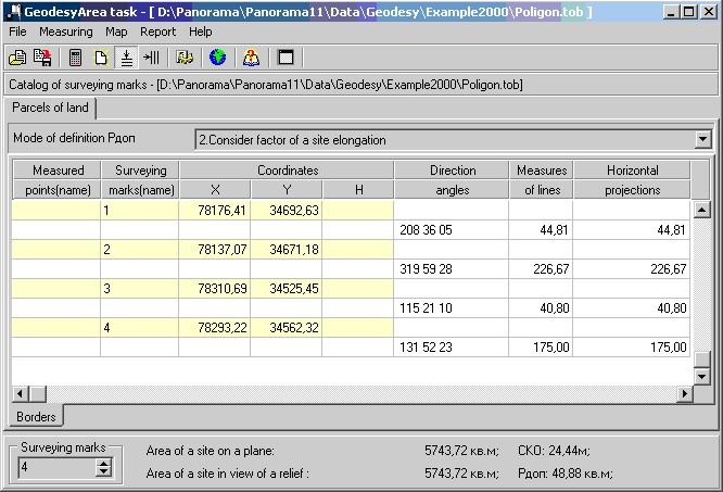
After opening the dialogue Geodesy Area task is necessary to set some parameters. - mode of definition Рдоп; - quantity of surveying marks if data input will be carried out manually.
In the opened window to enter into the table the initial data or manually (example), or from earlier created file of initial data (Open item in the File menu or the Open toolbar button; the name of the open file of *.tob format - the catalogue of surveying marks - will be shown above the table). At input of initial data manually if preliminarily the theodolitic course has been constructed or the direct geodetic task has been counted at presence in these tasks of a point with the entered name then its coordinates will be entered into the table automatically. If necessary it is possible to correct data (it is important: upon termination of correction of the table cell it is necessary to press Enter). After the initial data are entered it is possible to save them in a file of *.tob format for their repeated use in the further (Save as ... item in the File menu or the Save as ... toolbar button). To press the Calculate toolbar button or Compute item in the Measuring menu. The admissible error of definition of area Рдоп is defined according to the chosen mode of definition Рдоп. Choose the mode necessary to you from the drop-down list (Mode of definition Рдоп). Modes of definition Рдоп: 1. By formula: Рдоп = 3.5 x Mt x ЦP, sq.m where Mt - an average quadratic mistake of position of land-mark (it is set in settings on "Admissions" page, is taken from the table «Normative accuracy of a land-surveying of land management objects») 2. Consider factor of a site elongation: Рдоп = 2 Х mp, where mp - an average quadratic error of definition of the area of the ground site, calculated by the formula: mp = Mt Х ЦP х Ц(1+K2) : 2K; where P - the area of the ground site, K - factor of elongation, Mt - an average quadratic mistake of position of land-mark (it is set in settings on "Admissions" page, is taken from the table «Normative accuracy of a land-surveying of land management objects») If K= 1 (a site of the square form) mp = = MtХЦP ;
The received results can be saved in the form of the calculated sheet (Report menu or the Create report toolbar button). Thus, results of calculations can be seen at first in Word, and in the further this sheet can be saved or printed out by means of Word). For creation of such sheet it is necessary, that there was a pattern for the report. The received results can be plotted Map/Put the objects menu item or the To plot toolbar button). At an execution of the given procedure, plotting will be made onto a map of designing and onto an on duty cadastral map (DCM). Drawing onto DCM has one feature, polygon object - a site and its points of angles of turn - settlement points (calculated points), are created as a set of objects. The main object of a set is a site, rotary points - are the subordinated objects. Thus, it is possible always to request the name of any rotary point of a site, through the generated links though the polygon object has no opportunity for storage of the name of each point. This feature of drawing is used at formation of the report by registration data. Upon termination of processing the entered initial data all window can be cleared (Clear the table toolbar button or Clear the table item in the menu Measuring menu) and to process new data or to close dialogue.
|