Example of data input into table for solution of direct geodetic tasks |


|
|
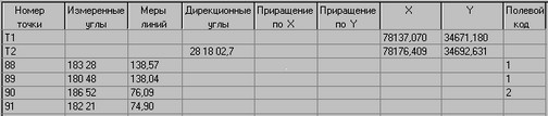
where Т1 - a point of guiding, Т2 - a point of standing.
Considering, that direction angles of initial directions in a direct geodetic task are defined onto a point of standing, we set a direction angle equaled 180 degrees for the device oriented onto the north. At an execution of field works the survey points have the coding defining a belonging of a point to the object on district. In the classifier of a map the all measured points have one classification code. For the specifying of a point's belonging the semantic characteristic FIELD CODE is filled for this point. Values of the characteristic are specified in the table. Such technique allows to define unequivocally in the further the points of field survey by their belonging to contours of district. Input of points can be done from table of a database «Catalogue of coordinates» by name of point as follows: to enter a name of a point into a corresponding column, to press the right mouse button and from the contextual menu to choose item Insert from catalogue. By the menu item Copy into catalogue it is possible to write down the calculated point into a database, having chosen a name of a point from the first column. (More in detail see use of catalogue of coordinates).
|