Connection bookmark |


|
|
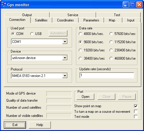
Connection bookmark is intended to set port parameters and to customize connection with GPS\ GLONASS receiver.
Connection of the device to a computer through COM-port: 1. First it is necessary to specify in Used port group the type of port - COM. Specify number of a serial port of a computer to which GPS receiver is connected. Set the Update rate to port for inquiry of the information from the device. By default Update rate is equal to 1 second.
2. Data rate is selected according to settings of the receiver. It is recommended to specify model (firm) of your receiver in the list of devices. If the model in the list is absent, choose "unknown device". 3. The list contains the following devices : - Magellan (MERIDIAN). Functionality, implemented on the Service bookmark, is applicable to devices of this series. When you select a row Magellan (MERIDIAN) the Service bookmark is renamed into Magellan, all modes becomes available for execution. - Javad (MAXOR). GPS-receiver of series MAXOR, developer company - Javad Navigation Systems. When selecting from a list this device the program sends a command of initialization to the device. After receiving the command the device begins delivery of messages in format NMEA 0183 on the COM-port of the computer. - Modem CellRoute-GPRS (TelecomFM Input). It is used to establish a connection with other modem-GPRS connected to receiver GPS. Device CellRoute-GPRS (TelecomFM) is in a waiting mode of a call. At receiving a signal from the subscriber the program gives a command to receive data - "pick up the phone". - Modem CellRoute-GPRS (TelecomFM Output). It is used to establish a connection with another modem-GPRS connected to the receiver GPS. At a choice of this device the program is in a waiting mode of call sending. Dialing the subscriber is carried out on the Output bookmark. - GeoRTK. Interface software GEO-RTK for geodetic receivers of Open Society RIRV. 4. Specify in GPS\GLONASS receiver the protocol format - NMEA0183. 5. Specify in GPS\GLONASS receiver the system of coordinates for delivering coordinates of current point WGS-84.
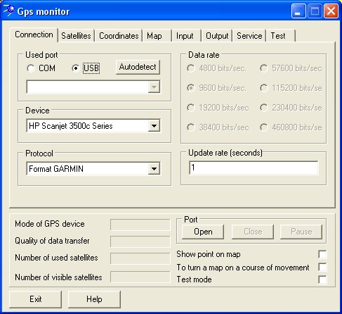
Connection of the device to a computer through USB-port: 1. Connect the device to a computer. 2. Switch on the device. 3. If necessary, install the driver of the device. 4. Specify type of port: USB in Used port group. The program will automatically try to detect the connected devices to USB. The list of the connected devices is formed in Device group.
5. Choose in the list of connected devices your Gps-receiver. If it was not possible to detect the device in the list, check up correctness of connection of the receiver to a computer, a correctness of installation of the device driver and repeat the attempt, by clicking on the Autodetect button. 6. In Protocol group specify Format GARMIN. 7. Specify Update rate to port for inquiry of the information from the device. By default Update rate to port is equal to 1 second. 8. Specify in GPS receiver a format of the exchange protocol - GARMIN. 9. Specify in GPS receiver the system of coordinates for delivering coordinates of current point WGS-84. After execution of the aforementioned settings it is necessary to open port by means of the Open button. After pressing the Open button the connection with the receiver becomes active. Accordingly, the Close button breaks off the connection. Pause button is intended for the temporary stoppage of updating the information fields of dialog. Connection with the receiver thus is not turned off. The messages sent by the device continue to collect on Input bookmark. Mode of creation on a map of route or points of route by coordinates from GPS receiver also does not be interrupted. For renewal of filling the information fields of dialog click again by the Pause button. At correct opening of a port and successful connection with the receiver from the device the information immediately starts to go, this information is displayed on the Input bookmark. After the GPS receiver has been oriented and has caught not less than 3 satellites, it is capable to define the coordinates, which are displayed on the Coordinates bookmark. To enable navigation click on the button «Start Tracking (Garmin USB)» on the Service (GARMIN) bookmark. Scheme of conventional location of the satellites on the celestial sphere, the accuracy of measurements are displayed on the Satellites bookmark. For displaying the received point on your map use the check-box: Show a point on the map. Thus, the map moves so that the point (indicated by blinking cross-hairs or by the conventional sign specified on the bookmark Parameters) appears in the middle of a document window. At tracking moving object for orientation of a map on a course of movement use a tick: To turn a map on a course of movement. Parametres of map turn it is possible to change on the Parameters bookmark. If there is no possibility to experiment with GPS receiver, to get acquainted with work of the task GPS\GLONASS - Monitor it is possible, having included a test mode (Test mode check-box). The choice of a testing mode is carried out on the Test bookmark.
|


