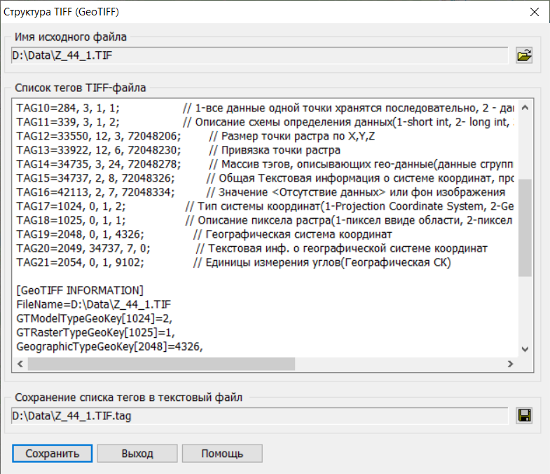
Structure of GeoTIFF file in Lat/Lon projection (EPSG code 4326)

Print Previous page Top page Next page

Viewing GeoTIFF file tags in projection with EPSG 4326 code:


taglist1


[TIFF INFORMATION]


FileName=D:\Data\Z_44_1.TIF


TagsAmount=21


TAG1=256, 3, 1, 6000;

// Image width

TAG2=257, 3, 1, 6000;

// Image height

TAG3=258, 3, 1, 16;

// Element size (bits per pixel)

TAG4=259, 3, 1, 1;

// Compression method(1- without compression, 2- CCITT/3, 3- FAX CCITT Group3, 4- FAX CCITT Group4, 5- LZW, 32773- PackBit)

TAG5=262, 3, 1, 1;

// Color model(0.1- halftone palette, 2- RGB, 3- RGB palette, 4- mask, 5- CMYK)

TAG6=273, 4, 6000, 72000206;

// Pointer to the image (table of offsets to the image)

TAG7=277, 3, 1, 1;

// Number of color layers(1- b/w image, 3- three color layers)

TAG8=278, 3, 1, 1;

// Number of uncompressed lines of one strip

TAG9=279, 4, 6000, 72024206;

// The number of bytes of the corresponding strip

TAG10=284, 3, 1, 1;

// 1-all data from one point is stored sequentially, 2 - image data is divided into planes and stored in layers

TAG11=339, 3, 1, 2;

// Description of the data definition scheme(1-short int, 2- long int, 3-float, 4-undefined data format)

TAG12=33550, 12, 3, 72048206;

// The size of the raster point in X,Y,Z

TAG13=33922, 12, 6, 72048230;

// Binding a raster point

TAG14=34735, 3, 24, 72048278;

// Array of tags describing geo-data (data is grouped into quadruples)

TAG15=34737, 2, 8, 72048326;

// General textual information about the coordinate system, projection, ellipsoid ...

TAG16=42113, 2, 7, 72048334;

// The value of <No data> or the background of the image

TAG17=1024, 0, 1, 2;

// Type of coordinate system(1-Projection Coordinate System, 2-Geographic latitude-longitude System, 3-Geocentric (X,Y,Z) Coordinate System)

TAG18=1025, 0, 1, 1;

// Raster pixel description (1-pixel as an area, 2-pixel as a point)

TAG19=2048, 0, 1, 4326;

// Geographic coordinate system

TAG20=2049, 34737, 7, 0;

// Text info. about the geographic coordinate system

TAG21=2054, 0, 1, 9102;

// Angle units (Geographical CS)


[GeoTIFF INFORMATION]

FileName=D:\Data\Z_44_1.TIF

GTModelTypeGeoKey[1024]=2,

GTRasterTypeGeoKey[1025]=1,

GeographicTypeGeoKey[2048]=4326,

GeogCitationGeoKey[2049]=WGS 84

GeogAngularUnitsGeoKey[2054]=9102,

ModelPixelScaleTag[33550]ScaleX=0.000833,

ModelPixelScaleTag[33550]ScaleY=0.000833,

ModelPixelScaleTag[33550]ScaleZ=0.000000,

ModelTiepointTag[33922]I[0]=0.000000,

ModelTiepointTag[33922]J[1]=0.000000,

ModelTiepointTag[33922]K[2]=0.000000,

ModelTiepointTag[33922]X[3]=35.000000,

ModelTiepointTag[33922]Y[4]=60.000000,

ModelTiepointTag[33922]Z[5]=0.000000,