Contour line generalization |


|
|
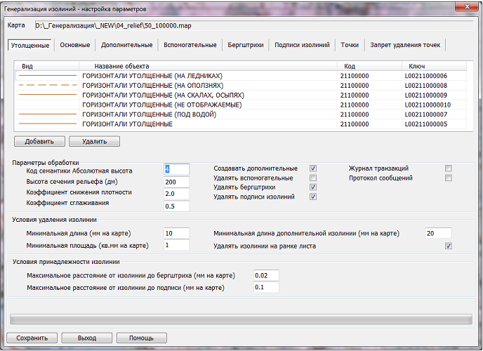
When processing horizontal lines, the height value is requested from the semantics, the code of which is set by the parameter of the dialog "Semantics Code Absolute Height." When removing horizontal lines of small length and area, parameters specified in the group "Contour Line Removal Conditions" are used: "Minimum Length", "Minimum Area", "Remove Contour Lines on Sheet Frame".
When transforming the type of horizontal lines, continuity of the location of the line is ensured (on land, on glaciers, on landslides, etc.). The metrics of the obtained horizontal lines can be smoothed. To do this, when setting the parameters, you should specify the "Smoothing Coefficient" (a number greater than 0 and less than 1, recommended value 0.5). When the smoothing coefficient value is zero, metric smoothing is not performed.
During processing, hachures that do not belong to any sheet horizontal line are removed. Such hachures remain on the map after horizontal lines are removed. The types of processed hachures are contained in the "Hachures" dialog tab. The parameter "Minimum Distance from Contour Line to Hachure" is used to determine ownership.
During processing, labels of horizontal lines that do not belong to any sheet horizontal line are removed. Such labels remain on the map after horizontal lines are removed. The types of processed labels are contained in the "Contour Labels" dialog tab. The parameter "Minimum Distance from Contour Line to Label" is used to determine ownership.
If the processing parameters include the mode "Create Additional", then the resulting additional horizontal lines can be thinned, meaning a reduction in density. To reduce the density of additional horizontal lines, when setting the parameters, you should specify the "Density Reduction Coefficient" (a number greater than 0 and less than 10, recommended value 2). When the coefficient value is zero, density reduction is not performed. During thinning, the length of the additional horizontal line may decrease. If the resulting length is less than the parameter "Minimum Length of Additional Contour Line", then the additional horizontal line is removed. The process of reducing the density of additional horizontal lines is displayed with a separate progress bar.
During processing of point objects with absolute height, some point objects may be removed or transformed into objects of another type. The types of processed point objects are contained in the "Points" dialog tab. The parameter "Density (points/sq.dm)" is used during processing.
Диалоговое окно генерализации изолиний:
The height of the relief section of the derivative map is set from the task parameters file "Formation of the Nomenclature Sheet of the Derivative Scale Map" (file with the extension IUN). The task "Relief Generalization" completely eliminates manual operations when aligning contour lines, hachures, and contour labels in accordance with the requirements for creating derivative scale maps. Replacing manual operations with automatic processing speeds up this stage of derivative map creation.
The quality analysis of the derivative map is carried out based on the error protocol (messages) obtained after the formation of the nomenclature sheet of the derivative scale map in the "Map Editor — Control Results" dialog. |