Generalization of point objects with absolute height |


|
|
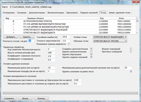
It is performed after processing the horizontal lines of the sheet. Objects are processed, the types of which are contained in the "Points" dialog tab. The types of point objects in the "Points" tab are arranged in descending order of their priority: geodetic points, command heights, height marks. Processing uses the parameter "Density (points/sq.dm)", which determines the number of command heights and height marks to be removed. During processing, excess height marks on the sheet are removed, and command heights are converted into height marks. The transformation of point objects is provided by elements in the "Special Points" and "Regular Points" dialogs. Point objects specified in the "Special Points" dialog element (command heights) are transformed into objects specified in the "Regular Points" dialog element (height marks). During processing, a search is conducted to save the four command heights with the highest absolute height in the quarters of the sheet. If a command height matches a geodetic point, it is also saved. If the "Lower Visibility Boundary" mode is set, instead of removing excess height marks, a new upper visibility boundary is established to prevent displaying excess height marks in a derived scale.
Random errors, specified by the "Random Error" parameter, are introduced into the coordinates of geodetic points. The coordinates of geodetic points are rounded according to the "Rounding Accuracy" parameter. When zero values are set for these parameters, the coordinates of geodetic points remain unchanged. When processing height marks, a check is performed to determine if the marks belong to objects that prohibit their removal. Objects that may prohibit the removal of height marks include: summit mark (mountains, hills, ridges), administrative boundaries, linear or areal rivers for which the height mark is a trimble point. The types of objects that prohibit the removal of height marks are listed in the "Prohibited Point Deletion" dialog tab. The belonging of a height mark to a prohibiting object is determined using the "Topological Link Tolerance" parameter.
To check the number of height marks, it is recommended to set up a grid on the map (via the "View - Display Grid" menu). The grid spacing is set in the "Map Grid" dialog (via the "View - Grid Parameters" menu). Setting the grid spacing to 100 millimeters on the map will result in a square formed by grid line intersections equaling 1 dm² of map area. Disabling the grid (after completing the selection) is done by turning off the grid display mode in the "View - Display Grid" menu.
The "Points" tab contains a list of processed objects and editing fields: — Random error (meters on site); — Rounding accuracy (meters on site).
Points tab
Deletion of objects is performed automatically. After automatic generalization, objects are selected (deleted) if there are more than 12 objects per 1 dm² of area. The selection (deletion) of objects is carried out in accordance with the requirements of regulatory documents in the following order: — Points of the State Geodetic Network (SGN); — Survey network points (densification points of geodetic networks); — Benchmarks and marks of the State Leveling Network; — Astronomical points; — Command height marks; — Other height marks; — Height marks at a landmark; — Height marks below sea level.
Automatic introduction of random error into the coordinates of planimetric points according to the set dispersion value allows replacing manual movement of corresponding objects and significantly speeding up the process of creating a derived map. The "Prohibited Point Deletion" tab contains a list of objects that increase the priority of "Height Marks" objects and proximity to which prohibits the deletion of height marks. Height marks located near objects such as "Boundaries," "Rivers," and "Mountain Peaks" are not deleted. When processing height marks, a check is performed to determine if the marks belong to objects that prohibit their removal. Objects that may prohibit the removal of height marks include objects like "Summit Mark" (mountains, hills, ridges), "Administrative Boundary," "Linear or Areal River" for which the height mark is a trimble point. The types of objects that prohibit the removal of height marks are listed in the "Prohibited Point Deletion" dialog tab. The belonging of a height mark to a prohibiting object is determined using the "Topological Link Tolerance" parameter. |