Formation of XSD scheme by classifier |


|
|
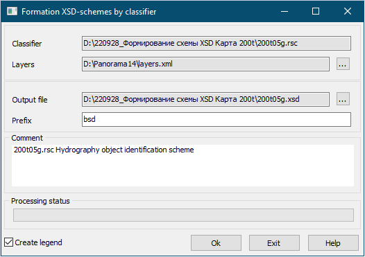
The program is intended for formation of the applied XSD-scheme according to the specification of data of exchange by digital topographic maps in format BSD (Base Spatial Data). To create a scheme, the program uses the attributive information of digital map classifiers. The applied scheme is used to transfer the attributive (semantic) characteristics of objects, codes and keys of objects, classifier layers when exporting/importing data in GML and GeoJSON formats, in the operation of geoportals, as well as when transferring data through a service according to OGC WFS standards. The file of BSD format is an applied scheme written in language of describing the structure of XML-document XSD (XML Schema definition). The declaration of types and elements complies with the W3C recommendations of the XML Schema specification and corresponds to the type of object attributes. When creating an XSD schema, a list of generalized vector data layers can be used. This is an XML format file corresponding to a specific RSC resource file. The file can be created with a text editor. An example of the list of layers.xml layers is given in Appendix 1 of the GML Specification for DTM (Program Files\Panorama15\Documents.En\Data Formats). The layers file is located in the application's folder with the executable module: Program Files\Panorama15. The choice of the layer list file name in the XSD schema generation dialog is not a necessary condition for the program execution. The layers.xml XML file is used as a filter for the layers that are brought into the XSD schema. If there is no list of layers, all layers of the RSC resource file specified in the Classifier dialog field are entered into the scheme. The Prefix field specifies the namespace for the schema. If the field is empty, then the name prefix is set automatically in accordance with the name of the classifier. This field is necessary to identify nodes and attributes of different schemes, so that when using several schemes, one or another parameter can be uniquely identified. The Comment field adds a general semantic description of the scheme. For example: «Scheme of aircraft identification and flight safety». If the Create legend mode is set, then a subdirectory <RSC name>.icons is created in the directory of the output XSD file, in which images of object samples in png format are generated.
|

