Creating and Editing Map Object Metrics |


|
|
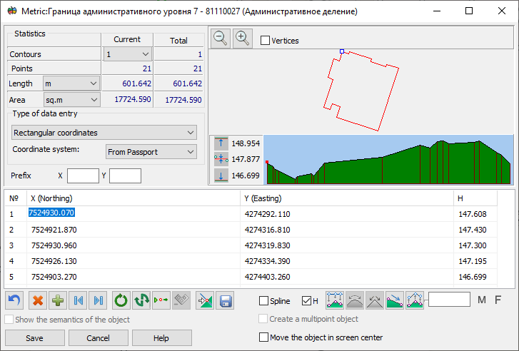
The map object metric creation dialog is designed for keyboard input of the metric description of the created object.
Object coordinate input can be performed in the left rectangular (X — up, Y — right) or geodetic (latitude B, longitude L) coordinate system. Switching to the geodetic coordinate system is only possible if the current map supports conversion from rectangular to geodetic system.
If the edited (created) object contains three-dimensional metrics, input of the absolute point height (H) automatically becomes available. If you enable the H option for a two-dimensional object and click the "Get height from matrix" button, points where there is an open height matrix on the current map will automatically receive the height taken from the matrix.
To add a metric characteristic, you need to enable the "F" or "M" option. A corresponding column will be added to the table. The "F" characteristic has an integer representation, while "M" has a floating-point representation of the value. The Spline option serves to enable (and disable) the dynamic spline feature for the edited object. The contour of such objects is built at the moment of display on the screen as an enveloping dynamic spline.
Input and editing of electronic map object points (in the X, Y system) can be performed in one of seven modes (switching modes during input is allowed): - direct input of rectangular point coordinates X, Y; - direct input of geodetic coordinates B, L in degrees (format G.g, G M.m or G M S.s) or radians; - input of increments dX, dY; - input of distances and directional angles, left or right turning angles, azimuths, or conventional directions (bearings).
In the direct rectangular coordinate (X,Y) input mode, prefixes can be used (automatic input of initial symbols that repeat for all input points in coordinate values). In the PrefixX and PrefixY lines, constant values are entered that will automatically be copied to the corresponding table cells before they are filled.
Editing increments (dX, dY) is possible in two modes: with coordinate fixation; and with increment fixation. In coordinate fixation mode, when editing the increment to the current point, only the coordinates of this point will change (the increments from the current point to the next will also change). In increment fixation mode, increments that existed after the edited point will be preserved (coordinates of subsequent points will be recalculated).
The input angle (direction) values can take the following forms: - directional angle (0-360° clockwise from north); - right and left turning angle (0-360°); - bearing (NE – 0-90° clockwise from north, SE – 0-90° counterclockwise from south, NW – 0-90° counterclockwise from north, SW – 0-90° clockwise from south, 90°NE = 90°SE, 90°NW = 90°SW, 0°NE = 0°NW, 0°SE = 0°SW).
At the bottom of the window is a toolbar with additional instruments. Undoing previous actions (up to 256 steps back) is possible until the object is saved or the coordinate input mode is switched. Additionally, it is possible to delete and duplicate the current point, quickly move to the beginning and end of the table, close, change direction and delete (except the main one) the current sub-object, as well as set the beginning of the sub-object to the current point (for a closed sub-object).
In the upper right part of the dialog window, a diagram of the object being created (edited) is displayed. You can zoom in and zoom out the image by pressing the corresponding buttons.
The position of the current point is displayed with a "punch mark". The current sub-object is displayed in two colors: blue — from the first point to the current point, red — from the current to the last point. All other sub-objects (if any) are displayed in brown.
When creating a point object by entering coordinates from the keyboard, enabling the "Show object semantics" option provides the ability to set semantic characteristics for the created object. The table displays semantics that are assigned to the object in the classifier and have the type of numeric value, character string, or code from the classifier. Processing of semantics of the "Code from classifier" type is carried out by double-clicking in the corresponding table cell.
If it is necessary to create multiple point objects, you can enter coordinates of several points in one table and set semantics. Based on this data, several objects will be saved on the map.
To speed up the process of creating an object using coordinates entered from the keyboard, the ability to copy and paste coordinate values using the clipboard (key combinations Ctrl+C, Ctrl+V) has been expanded. If the clipboard contains multi-line text and the lines have different lengths, when extracting data from the clipboard, the program automatically identifies and fills in the coordinate fields with a single execution of the Ctrl+V command. A space or tab character is used as the field separator in the table. Copying and pasting data is supported both in an individual field and in a selected range of table cells. |