Request of the map object description |


|
|
To request a description (brief reference information) of a map object: 1. Activate the digital map containing the object of interest. 2. Move the cursor crosshair over the object and press the left Mouse button or the ENTER key on the keyboard.
Dialog View
The digital map has a multi-layered structure. Several objects can be spatially located simultaneously at the point indicated by the crosshair. Therefore, after the first click, information about the topmost object will appear in the dialog window. Vertical layer-by-layer navigation is possible using the Forward
Dialog operation modes:
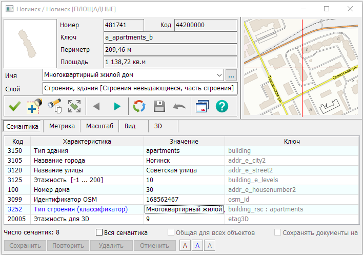
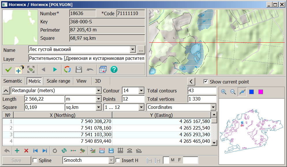
The dialog provides the ability to recode the selected object—clicking in the image window at the top of the dialog allows you to select a new object type. The top part of the dialog displays non-editable object characteristics: • Number - the unique or serial number of the object on the map; • Code - the classification code in digital or symbolic form; • Key - the object key in the classifier; • Perimeter or Length of the object; • Area for a closed object.
Switching between the unique number and the serial number is done by clicking on the word "Number". The field name for the serial number changes to "Number". To view the classification code in symbolic form, click on the word "Code". The field name for the symbolic classification code changes to "Code". For area and closed linear objects, the Perimeter field indicates the object's perimeter; for other localizations, it indicates the Length. For a multi-contour closed object, the perimeter is defined as the sum of the perimeters of all external contours. For an unclosed object, the sum of the perimeters of all contours is calculated. The area of an object with sub-objects is defined as the area of the object minus the areas of the sub-objects. For a multi-contour object, the areas of all external contours are summed, and the areas of internal contours (sub-objects) are subtracted. To obtain refined values for length and area, select the Refine area and length item in the Parameters menu. If this item is not selected, calculations are performed using the map coordinates. The letter "K" will be added to the Perimeter and Area field names. The units for displaying length and area are set on the Metric tab.
The dialog allows viewing and editing the main characteristics of selected objects, located in the lower part of the dialog as tabs.
Main tabs:
In the object selection dialog, semantics can be sorted by the following criteria: • Disabled; • Code; • Characteristic; • Value; • Key.
The sort indicator is saved in the Sort section of the application's INI file and is restored in the next session.
Menu items Select similar objects and Select objects by semantics. When selecting objects similar to the chosen one, a match is checked by layer, localization type, object code, and the value of the current semantics or the semantics selected on the Semantics tab. If the semantics on the Semantics tab in the current row is of the "File Reference" type, the context menu will additionally contain items Open in a separate window and Add to current document. Selecting the corresponding item will execute the command to open or add the relevant dataset (vector map, remote sensing data, etc.). On the Metric tab, the context menu includes the Display Order item, intended for selecting the property Topmost, Bottommost, Normal, which affects the object's position relative to other objects. When the "Normal" property is set, the object's display order is determined in the classifier by its layer, symbol type, and localization. On the Metric tab, the context menu includes the item "Save metric coordinates in EPSG:3857", intended for saving the object's metric in GeoJSON format in the Mercator projection on the WGS-84 sphere. The resulting file can be used to add objects to the "Public Cadastral Map". If errors related to incorrect file mapping occur, it is necessary to delete the panorama64.ini file. This file is located at: C:\Users\<username>\AppData\Roaming\Panorama15\panorama64.ini. The path to the file can also be opened through the Data Location window, where it can be viewed and deleted. |