Description of general information |


|
|
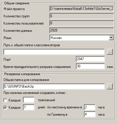
On the panel of general information the user can see the current path to the project file, see the information on quantity of data, users and groups, as well as set the application's language. The user can adapt the application to his language. For this purpose by any text editor it is necessary into section [LANGUAGE] of a file GISADMIN.INI to add a string with the name of your language (in English) L3=User_Language to copy completely section [RUSSIAN] and to translate values of all strings onto necessary language. The name of the section should correspond to the name of language (capital letters).
General information:
On the panel of common information the administrator can specify number of port for connection through which the GIS Server works. By default number of port is 2047. It is possible to specify time of forced disconnection at absence of messages. By default, connection is considered inactive or broken off at absence of messages within 30 minutes. All actions of users with GIS Administrator at saving a file of project write down into the text protocol of the program's work - file with a name of a file of the project and LOG extension. Text protocol is located in one folder with a project file. For ensuring a safety of results of editing of the vector data at failures of hardware and software the means of backup and data recovery are used. The user can set conditions at which performance a copying will be made: number of transactions executed with the specified data set and an interval of time in days (with specifying a time of copying). It is possible to set both conditions. In this case in the presence of changes a copying will be made by that condition which will be executed earlier. For the backup it is desirable to choose time of the least loading the server. It is possible to specify loading time by local time or by Greenwich Mean Time. In parametres system time is stored in GMT. If the data set did not change, the backup does not occur. The map classifier in a digital form is stored in the RSC file. RSC file is located in one directory with a vector map or in the general directory of classifiers. |