Operating procedure with catalogue of coordinates |


|
|
Getting coordinates from the catalog is supported in the dialogs "Construction and equalizing of a theodolitic course", "Direct geodetic task", "Return geodetic task", "Setting operation". Usually the catalogue of coordinates includes information about points of a fundamental geodetic net and points of thickening. Input and editing of data is provided by means of the dialog "Catalog of coordinates". To activate the mode, you must click the «List of Coordinates» button. When you open the dialog, the file will be automatically opened that was specified in the project's settings for surveying and land management documentation. If there is no corresponding setting, after entering the data, it is necessary to save them into a new file.
Maintaining information of coordinates catalogue:
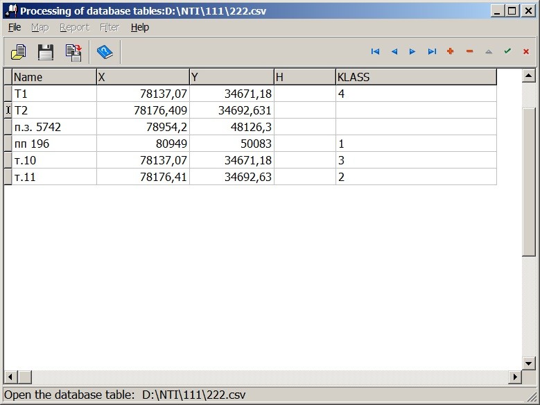
Dialogue «Catalogue of coordinates» provides creation and editing in elements of the screen form of file CSV that have the following set of fields: - NAME_9 - name of a point; - X - X coordinate; - Y - Y coordinate; - H - Н coordinate; - KLASS - a point class.
The CSV file must be in ANSI encoding. The delimiter of information fields is a semicolon (;). The fields NAME_9, X, Y and H must consist of an continuous character set, with no spaces. Fields X, Y and H allow only digits and a separator of the whole and fractional part - a period or a comma. Spaces are allowed when describing the «point class» field (KLASS). It is necessary to take into account that the main identification information in the catalog of coordinates is the name of the point, therefore filling of the NAME_9 field in the dialog positions is mandatory. Namely by the value of this field the search of necessary points for other modes will be carried out for the purpose of obtaining their coordinates. For moving between records in the table of the catalogue of coordinates, additions and removals of records, saving the entered data a set of navigator buttons is intended. Input of values is carried out in table cells. If you enter an existing point name, the program will issue a warning message: «Point with such name already is in the catalogue!», and the data will not be saved. Recording into the table can be repeated, having changed a point name. Use of points coordinates stored in the coordinates catalog in the forms of calculated tasks is performed as follows: - enter a point name into a corresponding element of the dialog window; - place the cursor on the element with the name of a point and click the right mouse button; - In the appeared pop-up menu choose the item «Insert from the catalogue».
The program will automatically find the point with the specified name in the catalog of coordinates and will transfer its coordinates to the form. The X, Y coordinates selected from the catalog will be entered in the corresponding elements of the dialog box. In case of absence in the catalogue of a point with the name typed by you receive the message: «Point with such name in the catalogue is not present!». For entering into the catalogue of coordinates of the calculated coordinates values of a point it is necessary: - place the cursor onto an element with a name of a point and click the right mouse button; - in the appeared pop-up menu to choose point «Copy into catalogue».
Data from corresponding elements of dialogue will be entered into the table of the coordinates catalogue. About it there will be a message: «Coordinates of the point «point name» are placed into the table «Catalogue of coordinates»: «table name». In case of duplicating a name in the catalogue of a point with the name typed by you receive the message:«Point with such name already is in the catalogue!», and entering of coordinates will not occur. Recording into the table can be repeated, having changed a point name. When specifying a point name, remember that when comparing this name with the name of a point in the table, it is takes into account the spacing in the spelling of the name, the font (English, Russian), and also the lowercase and upper-case letters.
|