Section Information on formed land plots |


|
|
Information for filling out the section on the created land plots is stored in the semantics of the cadastral object. The dialog for Parameters formation of cadastral documents is used for input and editing.
When completing the section in the report, markers specified in the table are used.
When filling out the information about the coordinate system (name #REFERENCE#, zone number #REFERENCE_ZONE#), the following algorithm is used: 1. Values are requested from the corresponding semantics of the cadastral object; if available, they are inserted into the report. 2. If the semantics values are not available, information specified in the settings of the Cadastral Documents module is used.
When filling out the table "Information on Characteristic Points of the Boundaries of the Created Land Plot" for marker #R5_1#, the following is requested: 1. Coordinates X and Y from the object's metric; 2. Designation of characteristic boundary points from the semantics NAME_9 of the point object — a characteristic boundary point located at the metric point of the plot. 3. Values for the method of determining coordinates, formula used for calculating the coordinates of points, and description of point fixation according to the following algorithm: — if a characteristic point is found and it has semantics METHOD, FORMULA, and DESKPOINT, these are used; — otherwise, values for these semantics are requested from the plot; — if these are also unavailable, values specified in the settings of the Cadastral Documents module are requested.
When filling out the table "Information on Parts of the Boundaries of the Created Land Plot" for marker #R5_2#, for each part, the following is requested: — horizontal projection — calculated based on the plot's metric; — description of the boundary part from the semantics BORDER.
To fill out the table "Information on the Formation of Land Plots through Redistribution", information about the redistributed parts is used.
The procedure for preparing a boundary plan map for the formation of land plots as a result of redistribution includes: — marking original land plots; — marking created land plots; — marking redistributed parts of plots; — filling out semantics for redistributed parts.
In the report and on the drawing, the designation of redistributed parts: — for parts of original land plots is presented as a colon, the land plot number in the cadastral quarter, a slash, and a combination of a lowercase letter "п" from the Russian alphabet with a number written in Arabic numerals (e.g., :123/п5); — for lands participating in redistribution with original land plots is presented as a colon, an uppercase letter "Т" from the Russian alphabet, a slash, and a combination of a lowercase letter "п" with a number written in Arabic numerals (e.g., :Т/п1).
For all parts created simultaneously as a result of redistribution from each original land plot, sequential numbering is applied (e.g., from :123/п1 to :123/пi).
Lands participating in redistribution with original land plots are numbered sequentially (e.g., from :Т/п1 to :Т/пi).
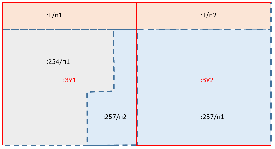
An example of a map for the formation of land plots designated :ЗУ1 and :ЗУ2 is shown in the figure.
Based on the results of mapping the original land plots, the following original plots should be present with cadastral numbers "50:16:000123:254" (designated as :254, filled in gray) and "50:16:000123:257" (designated as :257, filled in light blue).
As a result of mapping the created land plots on the cadastral map, the created plots should be present with designations :ЗУ1 and :ЗУ2 (with red boundary lines).
Based on the results of mapping the redistributed parts on the cadastral map, the following parts should be present (indicated by a blue dashed line): — :254/п1 – part of the original plot 254 (occupies the entire area); — :257/п1 – first part of the original plot 254; — :257/п2 – second part of the original plot 254; — :Т/п1 – first part of the land in the cadastral quarter; — :Т/п2 – second part of the land in the cadastral quarter.
The external boundaries of the redistributed parts must coincide with the boundaries of the original and created plots. The total area of all parts must equal the total area of the created plots. The external boundaries of the created plots must topologically match the boundaries of the redistributed parts, including those from lands that are in state or municipal ownership.
On the cadastral map presented in the figure, the redistributed parts are combined into land plots as follows: 1. :ЗУ1 consists of: — :254/п1 – part of the original plot 254 (occupies the entire area); — :257/п2 – second part of the original plot 254; — :Т/п1 – first part of the land in the cadastral quarter. 2. :ЗУ2 consists of: — :257/п1 – first part of the original plot 254; — :Т/п2 – second part of the land in the cadastral quarter.
When filling out the report in the section "Information on Created Land Plots", item 3 "Information on the Formation of Land Plots through Redistribution", the following algorithm is used to process the map.
In a loop, all created plots are iterated over. For each plot, a table with the designation of the land plot is inserted. For each created plot, a search is performed for redistributed parts located within that created plot.
For each redistributed part, a row is inserted into the table: — Column 1 – serial number — Column 2 – cadastral number of the land plot (accounting number of the cadastral quarter), from KADNUM_L; — Column 3 – area of the original plot, from semantics AREAINLAND; — Column 4 – designation of the part, from semantics MARKING; — Column 5 – area of the part, taken from semantics AREADOC.
All values are taken from the semantics of the redistributed part. An example of filling out item 3 "Information on the Formation of Land Plots through Redistribution" for the cadastral map in the figure is provided in the table below.
Example of filling out the section
При заполнении таблицы Сведения о характеристиках образуемого земельного участка используются маркеры, указанные в таблице.
When filling out the marker #FORMULA_S#, an algorithm is implemented that uses a variable selection of information from the semantics of the cadastral object or program settings: — if the object has a semantic value for the Formula for calculating area (1289, FORMULA_S), then this value is used for further actions; — if not, the value from the settings is used.
The obtained value is used to prepare the output inserted into the report and in the XML file in the position of the Formula applied for calculating the maximum permissible error in determining the area of the land plot, with substituted values and final (calculated) values (dP), m². | |||||||||||||||||||||||||||||||||||||||||||||||||||||||||||||||||||||||||||||||||||||||||||||||||||||||||||||||||||||||||||||||||||||||||||||||||||||||||||