Reading the cadastral plan of the territory and updating the map |


|
|
Processing of the following cadastral data schemes is provided:
The results of reading cadastral information are plotted on a cadastral map — a digital map in MAP, SIT, or SITX format. The cadastral map must be created according to the digital classifier survey.v5.rsc or survey.v6.rsc.
The cadastral map contains the following cadastral objects: 1. Cadastral quarters; 2. Land plots; 3. Real estate objects: — buildings; — structures; — unfinished construction objects. 4. Survey control points; 5. Boundaries: — boundaries of the Russian Federation and its subjects; — boundaries of municipal entities; — boundaries of settlements. 6. Zones and territories: — territorial zones; — zones with special usage conditions; — boundaries of water bodies. — characteristic points of cadastral object boundaries.
During the process, the procedure reads the original XML files to obtain attributes and coordinates of cadastral objects. The information obtained is used to add new objects and update existing ones on the cadastral map.
The cadastral map contains cadastral objects for which information is available in the Unified State Register of Real Estate as of the date of XML file formation. One XML file contains information about objects in one cadastral quarter. All cadastral objects have identification semantics (cadastral number or registration number). The cadastral map contains information about objects from multiple cadastral quarters.
When updating the cadastral map with information from XML files, the following situations arise: — there is no object on the map with identification semantics — new object; — there is an object on the map with identification semantics — existing object.
Three processing modes of the source data are used for updating the map: — add; — skip; — replace.
In the add mode, the program does not check for existing objects and simply adds all objects from XML files. This option works quickly and can be used in combination with pre-cleaning the cadastral map of all existing objects. However, information about extended cadastral objects (zones, boundaries) is contained in each XML file through which such an object passes. As a result, clones of such objects appear on the cadastral map.
In the skip mode, the program checks for existing objects. If an existing object is found, it remains unchanged. This option works slower than the add mode, but no object clones appear on the cadastral map. However, information about an existing cadastral object may change (area, address, material, etc.). In the skip mode, this information does not appear on the cadastral map. Only new cadastral objects are added to the map.
In the replace mode, the program checks for existing objects and updates their information with data from the XML file. This option works slower than the skip mode but ensures not only the absence of object clones but also updates information about existing objects.
Recommended steps:
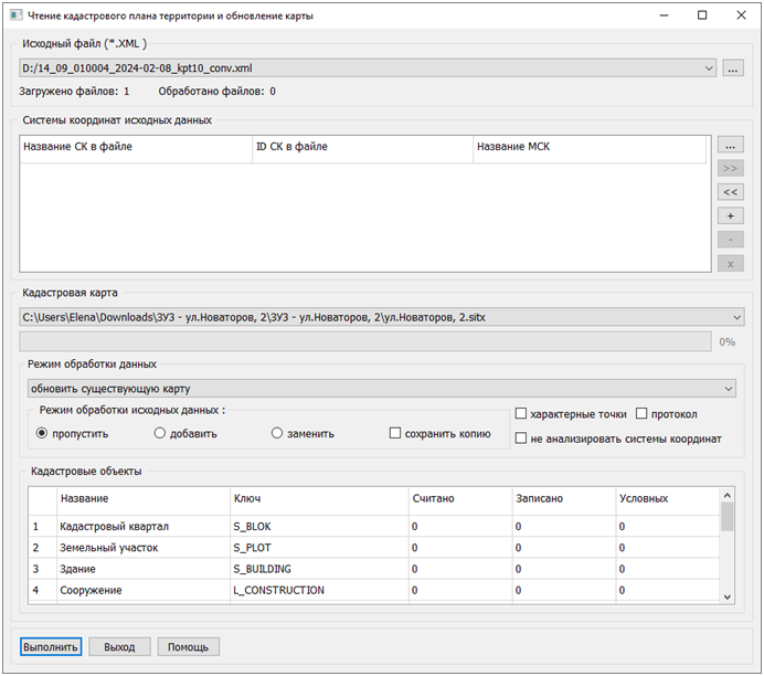
To select the uploaded cadastral information files in the Source File (*.XML) block, click on the button
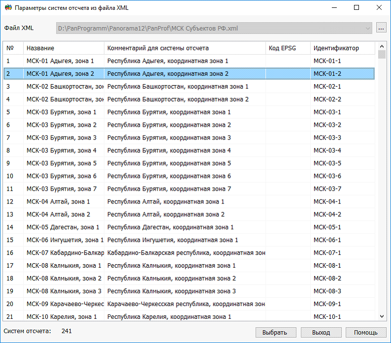
Configuring the coordinate system parameters of the source data involves filling out a table matching coordinate systems for MSK conversion parameters and is done in the Coordinate Systems of Source Data block using buttons located on the right side of the group. The list of correspondence between coordinate systems and MSK conversion parameters is stored in a correspondence file, containing information about the names and identifiers of coordinate systems in the source file, and the name of MSK in the file of coordinate system conversion parameters "MSK Subjects of the Russian Federation.xml". This information is displayed in the corresponding columns of the table in the Coordinate Systems of Source Data block.
The list of correspondence between coordinate systems and MSK conversion parameters can be prepared manually or in a semi-automatic mode. By clicking buttons By clicking the button
It is necessary to sequentially specify the MSK conversion parameters for each coordinate system of the source files. In the dialog Coordinate System Parameters from the XML file, select the row corresponding to the coordinate system described in the source data file. These parameters are used to convert coordinates of objects specified in the source files for recording on the cadastral map. By clicking the button By clicking the button By clicking the button
Using a correspondence file significantly reduces the time required to set up MSK conversion parameters when updating a cadastral map multiple times with different cadastral data for the same territory.
In the Cadastral Map block, specify the map for plotting the results of reading and processing the source data. The cadastral map should be created according to the digital classifier survey.v5.rsc or survey.v6.rsc, containing all necessary objects and attributes. The list of processed cadastral objects and their corresponding classifier keys is provided in the Cadastral Objects block.
Processing parameters for the source data are specified in the Data Processing Mode block. Choose from the dropdown list: — update an existing map; — create a new map for XML.
In the first case, the read data is written to the specified cadastral map in the Cadastral Map section. In the second case, new maps will be created for each XML source file.
Coordinates of cadastral objects read from XML files are converted to the coordinate system of the cadastral map. To analyze data in the coordinate system used for maintaining cadastral records of a specific object, check the box to save a copy. In this case, cadastral maps will be created for the original XML files, taking into account coordinate systems.
For processing data in creating a new map for XML, choose a digital classifier: — survey.v5; — survey.v6.
When reading source XML files with coordinates represented in a coordinate system matching a previously created cadastral map, you can check the box not to analyze the coordinate system of the XML file. In this case, no conversion of coordinates read from the source XML files will be performed.
Characteristic points of cadastral object boundaries contain information about point number, name, and measurement accuracy. However, in most cases, this information is redundant. To increase processing speed and reduce disk space occupied by the cadastral map, point objects corresponding to characteristic points are not plotted on the map by default. To plot point objects, you need to set a characteristic point flag for convenience in analysis.
For the convenience of analyzing the results of streaming loading of multiple files, a text protocol is generated. To record the protocol, set the protocol flag.
During the process of reading data and updating the cadastral map, the program displays in the fields Read and Updated the number of corresponding cadastral objects. The entries are filled with a cumulative total, showing the combined value from all source data files. For previously accounted cadastral objects (land plots, buildings, structures, and incomplete construction objects), in some cases, there is no coordinate description. To display information about such objects, a mechanism of conditional cadastral objects is implemented.
The coordinates of a conditional object are represented by a single point and are calculated using the following algorithms: — at the center of the cadastral quarter (for land plots); — at the center of the land plot (for buildings and structures); — at the center of the building (for premises). Information about the number of updated conditional cadastral objects is displayed in the Conditional field. |