Drawing a linear event |


|
|
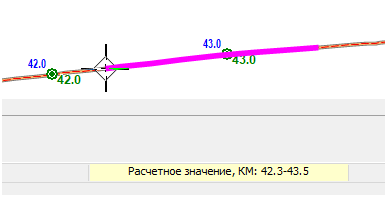
After activating the mode, you should select the object - route on the map where the event search will be performed. Only objects - routes with calibration points are available for selection on the map. After selecting the object, enter the value of the linear coordinate of the event. Input of the interval (linear coordinate of the start and end of the event) is done in the format 0.0-0.0 in meters or kilometers depending on the data input type set in the Map Editor parameters under the Service section. During the mode execution, you can change the input type by selecting the corresponding menu item that appears when you right-click. The entered value is displayed in the input parameters window at the bottom of the main window. The window is automatically activated when any numeric key on the keyboard is pressed. Additional activation by the mouse cursor is not required. Input is completed by pressing the Enter key. If one of the entered values is outside the range of linear coordinate values for the selected object, a warning will appear, and the search will not be executed. In case of a successful search result, the event will appear on the object's contour as a line. The beginning of the event will be marked with an additional marker. You can then proceed to search for another event by entering another linear coordinate value or save the found event on the route as a linear object. To do this, press Ctrl+Enter and specify the type of object to be saved on the map. If multiple maps are open, when choosing the object type, indicate which map to save the object to. Only maps available for editing will be present in the list. To switch to searching for an event on another route, press Ctrl+Right Click and select the desired map object.
|
 Linear event mapping involves placing a linear object on the map based on the minimum and maximum values of linear coordinate on a specified route.