Sorting and data compression |


|
|
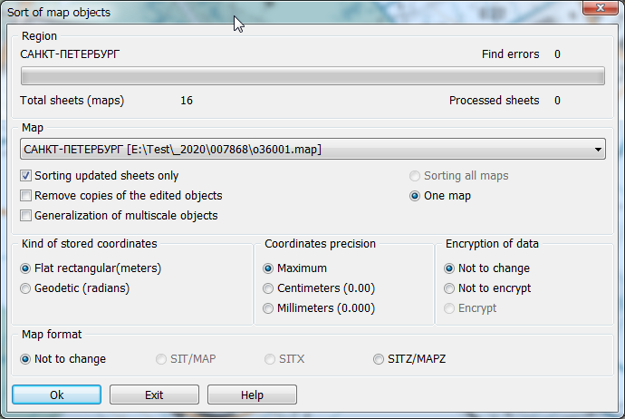
After an execution of any procedures changing the metric or semantic description of objects of a vector map (editing, updating, control, import of data, and also at editing the classifier if the order of displaying objects on a map is changed) - is recommended to carry out procedure of data sorting. Procedure of sorting orders the placement of object descriptions in files of the metrics and semantics that accelerates their further processing and provides correct sequence of displaying objects. Besides, created files do not contain the description of the metrics and semantics of the removed objects and a copies of the edited objects. Thus, compression of data is carried out. Sorting of map objects can change precision of a data storage (the number of decimal places after a comma) and system of saved coordinates of objects - flat rectangular in meters or geodetic in radians. Storing coordinates in radians accelerates display of maps when it is required to carry out recalculation in different projections of display «on the fly», and allows to create maps of any length in a longitude. Storage of coordinates in meters essentially accelerates display of a map in its own projection. For correct formation of the land-surveying documentation, calculation of lengths, the areas, the list of coordinates, etc. in addition it is recommended to install precision of storage in millimeters or centimeters. That will provide uniformity of results of calculation in all tasks (Geodesy editor, Map Editor, Calculations on a map, etc.) without additional parameters setting. If the mode is used Sorting updated sheets only, sorting will be carried out only for those sheets on which objects were edited. It reduces time of sorting. If the mode is used Remove copies of the edited objects, then after sorting it is impossible to restore the objects deleted or edited earlier. Thus the size of data on a disk decreases. If the Generalization of multiscale objects mode is enabled, then for objects of the RSC classifier having the Multiscale property, additional contours will be built by the generalization method. Sorting allows you to change format of a vector map. A multi-sheet map consists of a map passport (MAP file) and files for each sheet (metric - DAT, semantics - SEM, index file - HDR, graphic objects - DRW, display weights table - SIN). The user map consists of the map's passport (SIT file) and data files (metric - SDA, semantics - SSE, index file - SHD, graphic objects - SDR, the display weights table - SIN). The display scales table (SIN file) is created automatically when sorting the map or when creating maps of formats MAP, SIT and SITX. It is necessary for automatic ordering of objects according to the sequence of display specified in the RSC classifier. In the absence of a SIN file, objects are recorded only taking into account the type (linear object after polygons, point after linear, etc.). The user map and the multisheet map consisting of one sheet, can be written by one file of SITX format. The amount of data in the SITX file can be 5-10% more than when writing into several files. The SITX format simplifies the administration of data on magnetic media and allows you to restrict access to data by encoding with 256-bit code. Access to encrypted data is provided when entering a password. Multi-sheet map and user map can be packed into one file with data compression. Packed multi-sheet map has a MAPZ extension, a packaged user map - SITZ. To increase the degree of compression, the accuracy of the object metric is automatically converted to centimeters. The volume of the packed data decreases approximately in 3 times in comparison with volume of initial data with the maximum accuracy of a metric. Unpacking of data is carried out in memory in process of reading the corresponding sheets and objects. If the map sheet is located in memory entirely it is unpacked in a multiline mode at opening of sheet's data for access acceleration. The packed maps are accessible read-only. When sorting with the change of the data format, the files of the original map format are automatically deleted. Formats SITX, SITZ, MAPZ can be converted back to the original SIT or MAP formats by sorting. Packed maps with the reverse converting retain the accuracy of the metric in centimeters. The coordinates of objects in centimeters are stored in integers, which reduces the volume of metric files in 2 times. When placing data on the spatial data servers, it is advisable to use the MAP and SIT formats to reduce the access time. In desktop applications, the choice of format depends on the need to use data encoding, simplify the exchange of data in fewer files, provide a compact storage and other conditions.
|

