Import data from MIF/MID format |


|
|
The program «Import data from MIF/MID» is intended for formation of digital map in the format of GIS Panorama from data of MIF/MID format. Exchange format MIF/MID is presented by text files which contain a description of coordinates, attributes and external view (graphic representation) of map objects. Information about coordinates and graphic representation is stored in a file with MIF extension, and attributes of objects - in a file with MID extension. One pair of files MIF/MID represents one layer of a map and describes various graphic objects: lines, points, regions, titles on the map and so on. The map in format MIF/MID can consist of several layers, that is, several pairs of files of exchange format MIF/MID. Converter allows to import the data into the user map which is created automatically by the program, or is created by user in advance. The source data can be both in geodetic coordinates, and in rectangular.
During the conversion process, import of attributive information about objects is performed and its saving in the semantics of objects. In order to add a characteristic from the MID file into the semantics of an object, it is necessary that the semantics keys in the RSC classifier coincide with the attribute name specified in the header of the MIF file.
For example, to load the following characteristics, you need to have semantics in the RSC with the keys «id», «Name», «Value»:
Columns 3 id Char(10) Name Char(256) Value Float
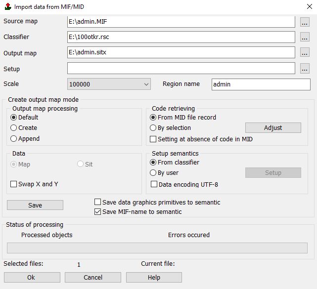
Components of the «Import data from MIF/MID» dialog are used to set up data conversion process:
To perform the conversion process, one or more files with the MIF extension, an RSC resource classifier, and the file name of the output map into which objects from MIF/MID will be imported must be assigned. The INI setup file is used to load several files of the same type or sets of MIF/MID files with the same settings of classification code and attributive data. The description and preparation of this file is considered in the Setup file help section. Specifying this file is optional. To start the conversion process, you must click the Ok button.
If you select Default in the Output map panel, the map will be created with the parameters specified in the MIF file in the CoordSys line. For example, for the line CoordSys Earth Projection 8, 104, "m", 39, 0, 0.9996, 500000, 0 Bounds (-7745844.29597, -9997964.94324) (8745844.29597, 9997964.94324) UTM topographic map will be created on a WGS-84 ellipsoid with a 39-degree center meridian and a FalseEasting axis offset of 500,000 meters. If you select the Create value, then in the Create map dialog you can enter the coordinate system parameters to which the coordinates from the MIF file will be recalculated (if the file coordinate system parameters are specified there in the CoordSys record). If you select the Append value, then objects from the MIF file will be appended into the selected map with recalculation of coordinates from the MIF file (if parameters are specified) to the map system (if parameters are specified in the map).
|