Calculating bulks of earth works |


|
|
The task determines the bulks of earth masses to be moved within a local area and also forms a work plan in the form of a user map. The task provides for calculation by two methods: by work points and by discretes (matrix elements).
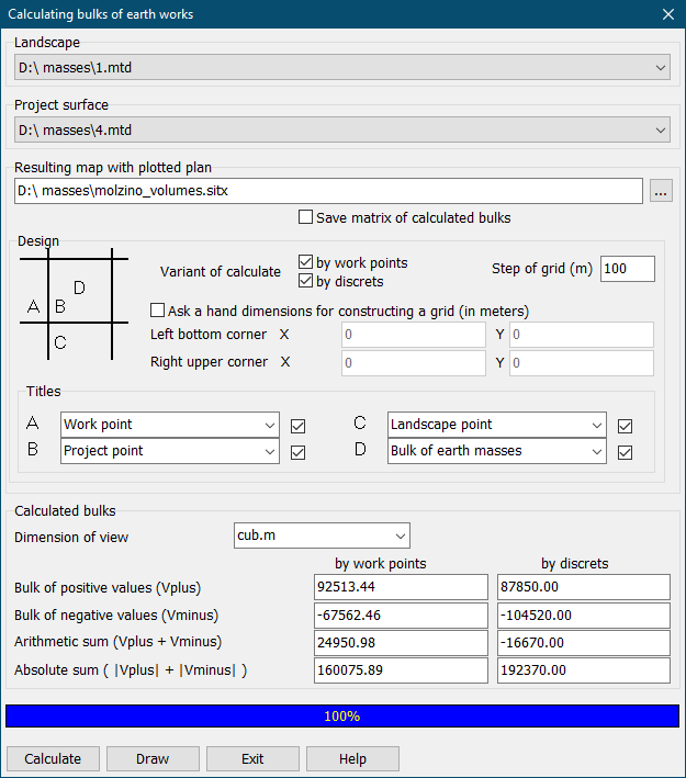
Initial data: - model of the original relief (topographic surface); - model of the project relief (the project surface); - construction parameters (value of the grid step of the plan, variant of calculation: by work points, by discretes or both options at once, method of setting the dimensions of constructing the grid: automatically or manually setting the coordinates of the left bottom and right upper corners of the grid in meters on the ground). Output data: - resulting user map with plotted plan of works and calculated bulks by a grid of squares; - numerical values of the calculated bulks, which are displayed in the corresponding dialog fields. Landscape models can be represented by a matrix of elevations (MTW) or a point cloud (MTD). To complete the task, it is necessary to have at least two terrain models represented by *.mtw or *.mtd files. The names of the selected initial models must be different, otherwise a warning will be issued and the calculation will not be available. The initial models must have an overlap area, otherwise a corresponding message will be displayed and the calculation will not be performed. When specifying the name of the resulting user map, the presence of a file with the same name is checked. If such a file already exists, a message will be displayed prompting you to change the name of the resulting map. After entering the grid step, it will be corrected taking into account the multiplicity in relation to the minimum element of one of the input matrixes, in a larger direction. For example, if an element of one of the matrixes is 25 meters, then when you enter a step of 40 meters, it will be adjusted to a value of 50 meters. The plan of earth works is the drawing in the form of a grid of squares with a user-specified side size. The less side of a square, the higher the accuracy of calculation. In corners of each square there are inscriptions (project points, points of landscape relief and work points). The dimensions of the grid of squares are calculated based on the dimensions of the relief models and the area of their overlap. However, the dimensions of the calculation area can be set manually if the automatically calculated dimensions of the grid do not suit the user. To do this, you need to set the appropriate mode on the form and enter the coordinates of the bottom-left and upper-right corner of the grid in meters on the ground into X,Y fields. In the task dialog, you can separately customize the types of signatures for each position and the option for placing signatures onto the plan (which signature should be displayed in which position). By default the following values are set: for A position - «Work point», for B position - «Project point», for C - «Landscape point» and for D - «Bulk of earth masses». The dialog provides the ability to disable the drawing of each position. The plan of earth works is plotted on the resulting map using graphic objects. To improve the readability of the plan, signatures of type G - «Bulk of earth masses» are applied in blue, the line of zero work is applied in green.
Between corners of squares with work points of different signs the points coordinates of zero work are calculated. After junction of points of zero works the line of zero works is created.
Depending on presence on the square's sides of points of zero works 2 types of squares distinguish: - homogeneous, when for all corners the signs of work points coincide, and on all square should be executed either an embankment, or hollow. The calculated bulk is deduced into the center of a square; - heterogeneous, when signs of work points at various tops do not coincide also a square is shared by a line of zero works onto sites of hollow and an embankment. The calculated volumes are deduced into the centers of sites.
If in one of tops of a square even in one of matrixes the height is not certain, the squares adjoining this top are not processed. The calculated bulks (bulk of positive values, bulk of negative values, the arithmetic sum and the absolute sum) are deduced into corresponding fields of a dialog box of the task. At calculation of bulks by work points for a homogeneous square the bulk of earth masses V0 is determined as volume of the prism having the area of basis P, equal to the area of a square, and the height equal to an average arithmetic from work points h of all four corners V0 = P * (h1+h2+h3+h4)/4. Bulks of earth masses in heterogeneous squares are determined after division by their line of zero works and by auxiliary lines (on the plan are not shown) onto separate figures - rectangular triangles, rectangles, trapezes, etc. Bulk of works Vr in separate figures is calculated by the formula Vr = Pr*hср, where Pr - the area of a separate figure; hср - an average work point of this figure.
At calculation of bulks by discretes of a matrix the surface (matrix) of qualities containing a difference of a project matrix and a matrix of landscape at first is built, with step equal to half of minimal step of one of entrance matrixes of heights. Then bulks of each element of a matrix of the qualities belonging the given square are calculated by formula Velem = h * Pelem, where h - value of a matrix of qualities. At a choice simultaneously of two variants of calculation the calculated values are deduced on a map one above another: from above by work points, under it in brackets - by discretes of a matrix In a heterogeneous square with two zero lines (it is divided into three parts) the value calculated by discretes of a matrix, is deduced the common value for two parts with an identical sign into the left top part of a square. |