Converter from S57 format

Print Top page Next page

This task is intended for converting information from the S57 format into the vector map format of the GIS Panorama system.

This version of the converter processes input data for the EN profile of the S57 standard and update data located in subdirectories according to the S57 standard.

The created vector map will correspond to the cylindrical conformal Mercator projection.


clip0001


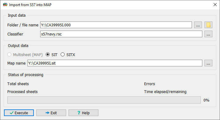
Input information for the task includes:

• An S57 data catalogue (extension .030) or a data file (extension .000);

• A resource classifier according to which the input map will be converted (extension .RSC).


The converter is supplied with a classifier file S57NAVY.RSC, which describes nautical chart objects and their attributes in accordance with the requirements of the S57 standard. The user may use this classifier or create their own.

After entering the input information, change the name of the output map area (initially it matches the name of the S57 format file without the extension) and the name of the output vector map (initially it matches the name of the S57 format file, but with the extension .MAP).

After completing the input data entry and adjusting the output data, click the Run button to start the conversion process.


During conversion, the user is provided with the following information:

• The number of sheets being converted (an S57 catalogue may reference several data files);

• The number of processed objects in the sheet being processed;

• The number of errors in the sheet being processed;

• The total number of errors across all sheets.


To interrupt the process, click the Abort button.


As a result of the conversion, the following is created:

• A vector map (.MAP), if an S57 data catalogue was selected as the input information;

• A user vector map (.SIT), if an S57 data file was selected as the input information.


The created vector map is opened and displayed automatically. After this, perform its sorting (the Sort item in the Tasks menu).


Map object codes, object attribute codes, and their values correspond to the codes of the S57 standard classifier. The following service attribute (semantics) codes have been additionally introduced:

• 32778 — the value of the FIDS subfield of the FOID field of the S57 standard;

• 32779 — the value of the FIDN subfield of the FOID field of the S57 standard;

• 32800 — the object code that has not yet been described in the classifier (.RSC);

• 32801 — the indicator of an object that has a reference to a subordinate object (depth soundings refer to labels);

• 32802 — the indicator of an object that is referenced by the main object;

• 32803 — the indicator of an object that is part of a group of peer objects (depth soundings are combined into groups).


The list of service semantics may be extended in the future.