Adjustment of isolines with linear objects of hydrography |


|
|
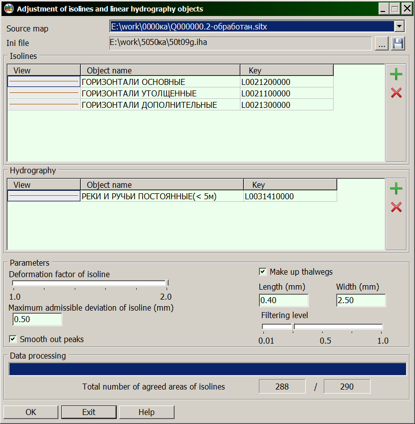
When combining the layers of vector map containing objects of hydrography and objects of a relief, received from different sources (by different technology) there is a problem of location mismatch of objects of a relief and objects of hydrography. This task is intended for bringing in conformity of contours of isolines concerning contours of the linear rivers. Thus, the artificial local deformation of isolines is carried out: - combination of extremums of isolines sections with contours of the rivers; - forming the extremums of isolines sections in intersection points of contours of isolines and rivers (at the extremums absence). This task should be performed only after control of absolute heights, so as at the matching of isolines with linear objects of hydrography the direction of a digitizing of isolines and objects of hydrography is considered. During processing, the points of intersection of a isoline with the next linear object of hydrography are defined. If the number of intersection points is more than 1, the message in the errors log is placed and processing the isoline is stopped. Matching of isolines with linear objects of hydrography is carried out by the module horadapt.dll which is called through the Run Application item of the Tools menu.
The program works in the dialog mode which window consists of several parts: - path of access and the name of files (input map, file of settings); - «Isolines» and «Hydrography» tables; - parametres of customizing the processing; - information fields about the status of map processing; - operating keys.
«Isolines» table can contain the following objects: - Isolines thickened; - Isolines main; - Isolines additional.
«Hydrography» table can contain the following objects: - Rivers, brooks constant; - Rivers, brooks drying up.
Parameters of adjustment: - Maximum admissible deviation of isoline (in millimetres on a map); - Deformation factor of isoline; - Smooth out peaks; - Make up thalwegs; - Thalweg length (in millimetres on a map); - Thalweg width (in millimetres on a map); - Filtering level.
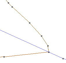
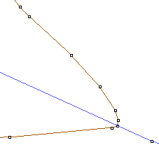
The maximum admissible displacement of a isoline defines the maximum length of displacement vector of an existing extremum of a isoline's section to a river contour. The deformation coefficient defines degree of deformation function. Smooth out the peaks - if you enabled it, a point is added onto each side from the extremum of coordinated isoline to smooth the sharp angle at the intersection point with the river: Without smoothing With smoothing
Form the thalwegs - at the enabled parameter the extremums of Isolines sections in intersection points of contours of Isolines and rivers (at the extremums absence) will be formed. In this case the Width parameter defines width of a formed thalweg (in half of width into each side from the extremum), and the Length parameter defines depth of a formed thalweg. Filtering level - allows you to change the number of points on the thalweg spline (0.01 - the maximum possible number of spline points, 1.0 - the minimum possible number of spline points). In connection with the selected parameters of adjustment, as well as the density of isolines on the map, the appearance of intersections of the deformed isoline with nearby isolines is possible, therefore, for each changed isoline, a check is made for intersections with objects from the «Isolines» table in the deformation area and, if such intersections are found, the isoline deformation is canceled.
All settings of mode the Matching of Isolines with linear objects of hydrography are saved in a file with IHA extension. Upon termination of process it is necessary to check quality of processing (Map Editor - View errors). The View errors log can contain the following messages explaining the reasons for absence of processing: - «Metrics of a isoline less than two points», - «Repeated crossing of isoline A and river B - № 1», - «Repeated crossing of isoline A and river B - № 2», - «Point of intersection of isoline A with river B is close to the beginning», - «Point of intersection of isoline A with river B is close to the end», - «Points of intersection of isoline A with rivers are too close», - «May be error in direction of digitizing of isoline A or river B», - «Too big divergence of contours of river A and isoline B», - «Error in determining the vector of deformation of isoline A to the river B», - «Section of river A has a complex form», - «Length of displacement vector of section top for isoline A is exceeded», - «Section top of isoline A is close to the beginning», - «Section top of isoline A is close to the end».
|