Description of the main program window |


|
|
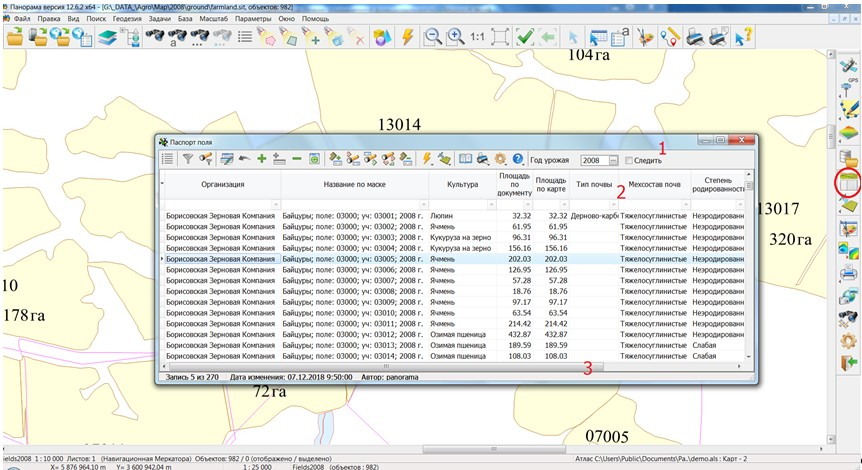
The main window Passport of the field opens over the open map. In the upper part of the window there is a control panel with modes of the Complex (1). Below it - the list of field passports containing the main field parameters from the database (2). At the bottom of the window there is a status bar (3).
The main window of the Passport of the field software after starting the program The control panel contains buttons that include the following modes of the complex:
Collecting field measurements: Export to offline map; Import from offline map; Creating field passports for selected objects on the map. Cities; Streets; Address point; Integrated delete an address. On passport field; For precision agriculture. Export to offline map. Land plots. Import data. Xml files (exchange with 1C); Export data. Xml files (exchange with 1C). Download vegetation index matrixes for object; Bulk download vegetation index matrixes for objects; Download vegetation indexes time series for object (NDVI); Viewing matrixes; Browse vegetation indexes time series for object.
Passport of the field; Card field; Report of agronomist; Structure of arable land; Gross collection from crop; Crop yields on the farm; Sowing the seeds; Plant protection means; Meliorator; Fertilizers; Structure of sown areas grouped by crop; Planned structure of sown areas; Doses of fertilizers.
Maintain user list and permissions to resources; Setting-up the path to templates for reports, change of the current organisation, setting-up the path to the data folders of Satellite monitoring; Mode «Minimize the dialogue in the search object».
The status line contains information about the number of the current record, the date of the last correction of the record and who edited the record.
Description of elements of the program status bar |