Program start

Print Previous page Top page Next page

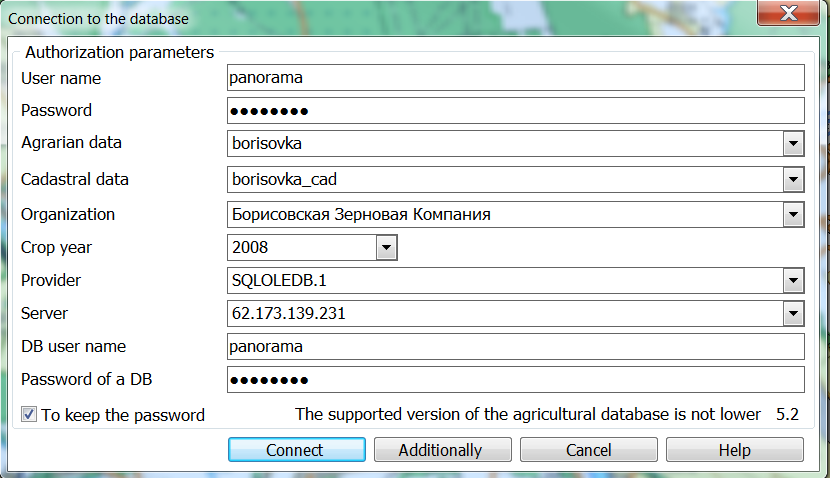
To start the program, it is necessary to do the following actions:

1. To start basic product the GIS Panorama or “Workstation of agronomist”.

2. To open a map. To work with demo data, you need to open the borisovka.mpt map project, which contains a set of demo maps. After installing the program, the map project file is located in the Windows user's documents folder, for example,

c:\Users\Public\Documents\Panorama\AgroMini13\Agro\borisovka.mpt.

3. Run the Complex. To do this, select the menu item Tools-> Run applications-> Complex of agronomic tasks.

4.On the Complex panel, click on the button ic_0408- «Passport of the field» section.

5. When the program is started, the «Connection to the database» dialog opens before the user. To display all connection parameters, click the «Additionally» button and fill in the dialog fields:

-        Parameters of connection with the server:

-        Provider - select from the drop-down list. If none of the Providers from the list is suitable, then you need to clarify the provider's name from the system administrator and enter it into the field.
-        Server - server name. For demo, specify the server ip address 62.173.139.13,1434.
-        DB username, DB password - login and password of a Microsoft SQL Server database user with administrator rights. For demo use login panorama, password panorama.

-        Parameters of the user authorization:

-        Username, Password - login and password of the Complex's user, which can only be created by a user with administrator rights. On first start, the program is configured for the panorama user with the panorama password, which is included in the list of system administrators. To ensure security and data protection, we recommend changing the password for the panorama user.
-        Agrarian data - a database for work with the Passport of the field. For a demo version specify borisovka.
-        Cadastral data - a database for working with land plots. For the demo version, specify borisovka_cad.

-        Additional settings for the Passport of the field list:

-        Organization - when setting an organization, the list of Passport of the fields is filtered by organization.
-        Crop year - when specifying a year, the list of Passport of the fields is filtered by a year of crop.
-        The values are selected from the drop-down list, which is formed according to the directories «Organizations» and «Crop year». At the first start the directory «Organizations» is empty. It is necessary to choose «Unknown organization» from the drop-down list. Filling in reference books is possible in the Passport of the field, Reference menu. Options of connection with the server are saved in the ini-file of the Complex. When you put check mark the Save password field, the entrance to the «Field passport» and «Satellite monitoring» will be performed automatically with the rights of the last user. Otherwise, the «Connection to the database» dialog will always be called. To change the user or other connection parameters, use the «Connection to the DB» ic_8041 button located on the «Agronomic editor» panel.

6. To complete user authorization and connect to the database, click the «Connect» button. If your authorization fails, despite the correctly entered data, then you do not have access rights to the «Passport of the field» software or your access is blocked. Contact your system administrator (see Administration of access rights).


Dialog «Connection to the database»:

_bm5408_png