Conversion of geodetic heights WGS-84 to normal heights |

|
|
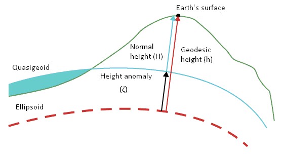
The task is intended for transition to heights on the geoid (normal heights) from geodetic heights on ellipsoids: common-Earth WGS-84 (World Geodetic System), GRS_80 (Geodetic Reference System 1980). Segment of the normal to the ellipsoid from its surface to this point is called a geodetic (ellipsoidal) height of a point of the physical surface of the Earth. Together with the geodetic latitude and longitude (B and L, respectively), it determines the position of a point relative to a given ellipsoid. Geodetic height depends on a location and parameters of the chosen ellipsoid therefore geodetic height is divided into two parts. One of them characterizes the physical surface of the Earth relatively the surface level, the second, a smoother, characterizes the difference of the counted ellipsoid from the geoid. Difference between a normal, geodetic and height of a quasigeoid is shown in the figure.
The task lets you convert to the normal heights (the average level of the world ocean) the matrixes loaded from the SRTM format (radar surveying), and also other matrixes in system of geodetic heights WGS-84. To convert the heights there are used the geoid models EGM2008 (Earth Gravitational Model) in the WGS-84 coordinate system. Models of a geoid are presented by matrixes in the MTW format with different cell sizes: with a step of 1 minute (http://gistoolkit.ru/download/geoid/egm8_1.zip) and with a step of 2.5 minutes (http://gistoolkit.ru/download/geoid/egm8_25.zip). When obtaining amendments of height from model of a geoid there is used a bilinear or a bicubic interpolation at the user's choice. |