Imaging of the vector information on the raster |

|
|
The mode is intended for displaying vector information into a raster map. The mode updates the image of the black and white raster by data from the vector map added into the document. To execute the mode, the document must contain a map with modified or updated objects and a black and white raster (with a color depth of 1 bit per pixel) that must be updated. The mode processes rasters with the element size of 1 bit per pixel. The main requirement for this mode is the updating the image part of the raster tablet without changing any characteristics of the tablet itself for subsequent delivery of it (raster tablet) to the appropriate administrative authority. During the execution of the mode, a black and white raster is created by copying the source file with the subsequent updating the selected area by information from the vector map included into the document. As a result of the mode execution, a new file with an updated image of the raster map is created whose characteristics (geospatial image binding, element size in meters on the terrain) fully correspond to the parameters of the initial raster.
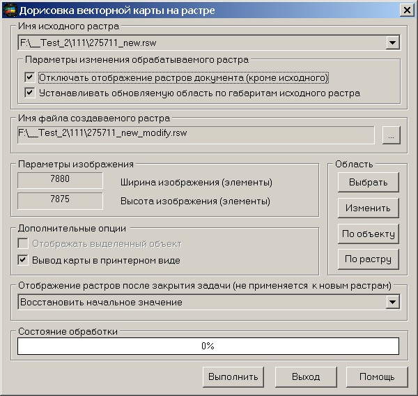
The mode carries out updating of the image of the black-and-white raster specified by the operator in the drop-down list «Name of the source raster». Name of the created file is automatically formed. The name of the created file is changed by the operator in the standard dialog of choosing a name of the saved file which is called by the button «…». When you start the task «Imaging of the vector information on the raster», the first raster from the list is set as the active one in the dialog. At change of a processed raster it is necessary to specify new area of saving (buttons «Select», «Change» …) which should be in dimensions of the chosen raster.
Choice and change of a saved fragment: For a choice of a fragment it is necessary to press Select button of dialog: Imaging of the vector information on the raster, then to note area on a map by a choice of two points. Dialog: Imaging of the vector information on the raster will open repeatedly. Change button is intended for change of the chosen fragment. By object button installs the sizes of saved area by dimensions of the chosen object. For drawing the chosen object into a raster it is necessary to switch on a tick: To display the selected object. By raster button installs the sizes of saved area by dimensions of the chosen raster. The choice and change of a fragment can be made repeatedly. On the sizes of a fragment and parameters of a source raster the width, height and the size (in bytes) of the saved image are estimated. For output of the vector information into a raster in a printer view it is necessary to switch on a tick View map in printer raster image. The button To not view other rasters of the document (except the source) is intended for automatic switching-off of displaying rasters of the document at change by means of the drop-down list «Name of the source raster» of a processed raster. Thus, when setting the mode, only the original raster with the vector map will be displayed on the screen. The button To install updated area by border of source raster is intended for automatic updating the saved area corresponding to the sizes of source raster, at change by means of the drop-down list «Name of the source raster» of a processed raster. Drop-down list the Mode of visualization of rasters after closing a task (it is not applied to new rasters) is intended for a choosing a degree of a transparency of displaying raster maps of the document after closing of task the Imaging of the vector information on the raster. This option applies to rasters added to the document before the task of Imaging of the vector information on the raster is started. The rasters that are automatically created and added to the document during executing the task of Imaging of the vector information on the raster will be displayed completely. By default, the line "To restore initial value" is selected, and when the task is closed, the program will restore the mode of displaying raster maps added to the document before starting the task of Imaging of the vector information on the raster.
To start the mode of Imaging of the vector information on the raster, you need to execute the menu item Tools\Run applications. In dialog the Run applications it is necessary to choose the mode of Drawing of vector map on raster from the tasks list in group the Thematic maps and diagrams. Start the task by clicking the Run applications button.
|