Editing information of metadata database |


|
|
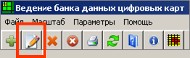
For viewing and editing the information on current record it is necessary to press button «Edit» on the main toolbar.
Editing records:
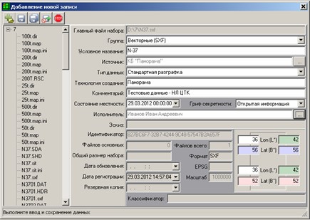
Description of the metadata of digital vector maps and plans contains the following information: -master file of a set - a full name of the main (first) file of a data set; -group - the group of data has its parameters of placing the data for the organization of long-term storage, recording, backup, selection and delivery; -code name - the nomenclature corresponding to the international rule, or a conventional name of a map. Nomenclature of the southern hemisphere can be written down with symbol addition “S” in front of the nomenclature. For example, “SN-37-001”; -source - an organization-manufacturer of a dataset; -data type - value of the data type is selected from the directory (nomenclature sheet of the digital topographic map in international rule, city plan, a map of the region in arbitrary borders); -technology of creation - the general information about the source data on which the map or the plan is created, and about technology of their processing; -state of the area - date of the state of the area to which a digital map or a plan corresponds (the date of survey and carrying out the field works); -performer - the person who uploaded the data set and entered the metadata in a databank; -preview - the filename with the preview image of a data set; -identifier - unique identifier of the data set, formed in the format “GUID”, for example,35940020-1AA0-4ABB-B9FC-C05C98EEE863; -main files - the number of files; -files in total - quantity of files; -security classification - the security classification of information is selected from the directory (open information, information with the limited access, information for internal use only, the classified information, absolutely classified information); -total size of the set - the total size of the data in kilobytes. Value of the field cannot be less than 1; -format - the format of the data set as an extension of the main dataset file; -EPSG - a code of coordinate system of a data set; -coordinates - geodetic coordinates of the bounding box corners of a data set, written down in degrees in geodetic system WGS-84; -scale - a denominator of base scale of a digital map or a plan. If value of the field is unknown, it can be set to “-1”; -update date - date of a data set creation. At creation of a new data set with the same name a new record of the metadata is created, and the set is added into storehouse in a separate folder; -registration date - date of formation of the metadata record in metadata base. -backup copy - date of backup; -classifier - the identifier of the classifier for a data set. -comment - the short description of a data set.
Description of the metadata of remote sensing data contains the following information: -master file of a set - a full name of the main (first) file of a data set; -group - the group of data has its parameters of placing the data for the organisation of long-term storage, recording, backup, selection and delivery; -code name (by default - a short name of a file); -source - an organization-manufacturer of a dataset; -data type - the value of the data type is selected from the directory (satellite imagery in the optical range, remote sensing in the optical with overlap for stereo pairs, aerial photography in the optical range, aerial photography in the optical with overlap for stereo pairs, multispectral photography, laser photography); -technology of creation - the general information about the source data on which the map or the plan is created, and about technology of their processing; -state of the area - date of the state of the area to which a digital map or a plan corresponds (the date of survey and carrying out the field works); -performer - the person who uploaded the data set and entered the metadata in a databank; -preview - the filename with the preview image of a data set; -identifier - unique identifier of the data set, formed in the format “GUID”, for example,35940020-1AA0-4ABB-B9FC-C05C98EEE863; -main files - the number of files; -files in total - quantity of files; -security classification - the security classification of information is selected from the directory (open information, information with the limited access, information for internal use only, the classified information, absolutely classified information); -total size of the set - the total size of the data in kilobytes. Value of the field cannot be less than 1; -format - the format of the data set as an extension of the main dataset file; -EPSG - a code of coordinate system of a data set; -coordinates - geodetic coordinates of the bounding box corners of a data set, written down in degrees in geodetic system WGS-84; -accuracy - number of metres on ground in one pixel of the image; -update date - date of a data set creation. At creation of a new data set with the same name a new record of the metadata is created, and the set is added into storehouse in a separate folder; -registration date - date of formation of the metadata record in metadata base. -backup copy - date of backuping; -classifier - the identifier of the classifier for a data set. -comment - the short description of a data set; -the symbol - a name of the device (satellite) from which survey is made; -the sun (angle, °) - the azimuth of the sun during survey in degrees.
Description of the metadata of matrixes of heights and terrain models contains the following information: -master file of a set - a full name of the main (first) file of a data set; -group - the group of data has its parameters of placing the data for the organisation of long-term storage, recording, backup, selection and delivery; -code name (by default - a short name of a file); -source - an organization-manufacturer of a dataset; -data type - the value of the data type is selected from the directory (Regular matrix of heights, TIN-model, cloud of points (laser photography)); -technology of creation - the general information about the source data on which the map or the plan is created, and about technology of their processing; -state of the area - date of the state of the area to which a digital map or a plan corresponds (the date of survey and carrying out the field works); -performer - the person who uploaded the data set and entered the metadata in a databank; -preview - the filename with the preview image of a data set; -identifier - unique identifier of the data set, formed in the format “GUID”, for example,35940020-1AA0-4ABB-B9FC-C05C98EEE863; -main files - the number of files; -files in total - quantity of files; -security classification - the security classification of information is selected from the directory (open information, information with the limited access, information for internal use only, the classified information, absolutely classified information); -total size of the set - the total size of the data in kilobytes. Value of the field cannot be less than 1; -format - the format of the data set as an extension of the main dataset file; -EPSG - a code of coordinate system of a data set; -coordinates - geodetic coordinates of the bounding box corners of a data set, written down in degrees in geodetic system WGS-84; -accuracy - number of metres on ground in one pixel of the image; -update date - date of a data set creation. At creation of a new data set with the same name a new record of the metadata is created, and the set is added into storehouse in a separate folder; -registration date - date of formation of the metadata record in metadata base. -backup copy - date of backuping; -classifier - the identifier of the classifier for a data set. comment - the short description of a data set. |