Specifying the ranges of roads visibility |


|
|
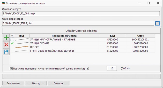
The task of Specifying the ranges of roads visibility is called through the Run Application item of the Tools menu. This mode is designed to simplify the road net in the base map scale. If there is an overloaded road net in the map, linear objects of the road network can paint over adjacent polygonal map objects (settlements and blocks). To improve the quality of the displaying the blocks, it is necessary to simplify the road net. The goal of the simplification of the road network is the assignment of a range of visibility to specific objects of the road net, corresponding to their importance. The degree of the road's importance is determined by the type of road, length and character of its location relative to other roads. In this task, two categories of objects are considered: priority and excluded objects. Priority objects are objects whose visibility will not change. Such objects include objects of the type: Streets main and high, Highways, Earthen country roads. Excluded objects are objects whose upper bound of visibility will be reduced by 1 level relative to the base map scale. Such objects include objects of the type: Other streets, Passages. Excluded objects can be transferred to the priority category in the following cases: - the priority object is adjacent to the excluded object; - excluded object has a length greater than the specified minimum length. By default this parameter is 10 mm on the map.
This dialog is presented as a table of processed objects. At work with the table the modes are available:
The field «*» is intended for assigning of excluded objects. Assignment is carried out by pressing the left mouse button. Excluded types of objects contain the sign To increase the priority of the object, taking into account the minimum length, it is necessary to set a tick in the corresponding field and enter the required value. After completing the customization of parameters it is necessary to press the Execute button.
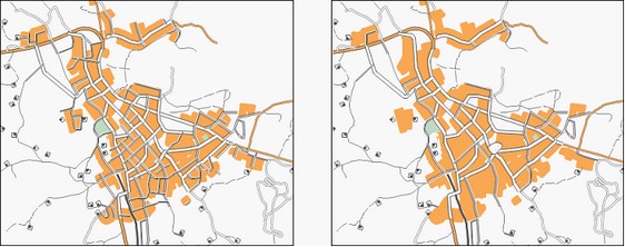
In the figure: at the left - the original image of the road network, on the right - the result of the automatic sparseness of the road net. |