Request of the map object description |


|
|
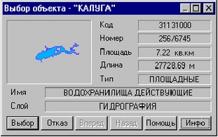
There is a possibility to request the map object description (brief help information) in Map 2011 system. It can be made as follows: - activate corresponding digital map; - place the cursor over object and press Enter or left mouse button. As a result you get a window, containing information about selected object.
Whereas the electronic map has multilayered structure, in a point specified by the mouse cursor, spatially several objects can be located simultaneously "under" the mouse cursor. Therefore, after the first pressing in a dialog window there will be information on the uppermost object. There is an opportunity of vertical layer-by-layer moving by pressing buttons: Next and Prev. Dialog allows to view and edit semantics the metrics, the displaying style and scale range of the chosen objects which are being under the mouse cursor on a map. At overstrike on Info button the detail information ceases to be displayed. The displaying of the object (subobject) metric includes some statistical characteristics, and also coordinates of its points and draft image. Following characteristics of object (subobject) are displayed: - number of subobjects; - ID of displaying subobject ( object has number 0); - number of points in object (subobject); - distance between current and following point of object (subobject); - azimuth angle from a current and to a following point of object (subobject). Coordinates of the metrics points can be displayed and edited in various units: - in meters in rectangular system of coordinates, - in map units in rectangular system of coordinates, - in pixels in rectangular system of coordinates, - in radians in geodetic system of coordinates, - in degrees in values range 1Е-6 - 1Е-7 in geodetic system of coordinates, - in degrees, minutes, seconds in geodetic system of coordinates.
If you edit object by changing distance and angle, coordinates of vertex that follows the current one are changed. You can not correct coordinates of the first object vertex this way. For editing heights in the metrics of object it is necessary to unfold the window of the help information on object. It can be made, having pressed the right mouse button over the dialog and to choose in the pop-up menu Full info item, and also by double click of the left mouse button on the heading of dialog. Besides by means of the Pop-up menu it is possible to execute following kinds of editing of the object metrics: - change of a digitizing direction of the object metrics, including subobjects; - change of a digitizing direction of the metrics of a current subobject; - deleting of a current subobject; - change of accuracy of representation of the object metrics.
Request of the map object description There is a possibility to request the map object description (brief help information) in Map 2011 system. It can be made as follows: - activate corresponding digital map; - place the cursor over object and press Enter or left mouse button. As a result you get a window, containing information about selected object.
Whereas the electronic map has multilayered structure, in a point specified by the mouse cursor, spatially several objects can be located simultaneously "under" the mouse cursor. Therefore, after the first pressing in a dialog window there will be information on the uppermost object. There is an opportunity of vertical layer-by-layer moving by pressing buttons: Next and Prev. Dialog allows to view and edit semantics, the metrics, the displaying style and scale range of the chosen objects which are being under the mouse cursor on a map. At overstrike on Info button the detail information ceases to be displayed. The displaying of the object (subobject) metric includes some statistical characteristics, and also coordinates of its points and draft image. Following characteristics of object (subobject) are displayed: - number of subobjects; - ID of displaying subobject ( object has number 0); - number of points in object (subobject); - distance between current and following point of object (subobject); - azimuth angle from a current and to a following point of object (subobject). Coordinates of the metrics points can be displayed and edited in various units: - in meters in rectangular system of coordinates, - in map units in rectangular system of coordinates, - in pixels in rectangular system of coordinates, - in radians in geodetic system of coordinates, - in degrees in values range 1Е-6 - 1Е-7 in geodetic system of coordinates, - in degrees, minutes, seconds in geodetic system of coordinates.
If you edit object by changing distance and angle, coordinates of vertex that follows the current one are changed. You can not correct coordinates of the first object vertex this way. For editing heights in the metrics of object it is necessary to unfold the window of the help information on object. It can be made, having pressed the right mouse button over the dialog and to choose in the pop-up menu Full info item, and also by double click of the left mouse button on the heading of dialog. Besides by means of the Pop-up menu it is possible to execute following kinds of editing of the object metrics: - change of a digitizing direction of the object metrics, including subobjects; - change of a digitizing direction of the metrics of a current subobject; - deleting of a current subobject; - change of accuracy of representation of the object metrics.
|