Control of matching the borders of digital topographic maps (DTM) in SXF format |


|
|
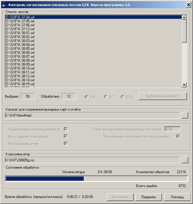
The program is intended for quality check of the coordination of adjacent sheets DTM (digital topographic maps) in formats SXF, SIT, SITX and issuing the reports in format DOC (MS Word). The program is operating in mode of control or control with editing the metrics of objects. To obtain DOC-File of the report, you must have in a computer MS Word, which is part of the package MS Office (2003 SP3 / 2007 / 2010). If the input data contains maps of different types the control of coordination of adjacent sheets is not carried out. For an execution of check of the matching the borders of DTM it is necessary: - run the program MapAdjustEx64.exe; - select processed SXF files - click the button «Select from directory» and select the directory that contains the source SXF-files; - choose the catalog for saving the report document (DOC-file) - click the button «…»; - select the classifier (RSC-file) - click the button «…»; - execute the control of matching - click the button «Execute».
Dialog of the program of matching the borders of DTM :
Quality check of the coordination of adjacent sheets is carried out in the following order: - if in dialogue the parameter «List of SXF sheets» is set, then there is carried out the import of sheets from format SXF into maps of format SIT in subdirectory NewMap created in the directory with input SXF-files; - checking the coordinates of corners of sheets frameworks: if passport coordinates of corners of frameworks differ from theoretical coordinates, then the program gives query to the operator for control interruption; - search of the objects going onto frames of adjacent sheets; - determining a presence of reply's objects on adjacent sheets; - check of a matching the metrics and semantics of objects of adjacent sheets of DTM; - filling the report document in format DOC (MS Word) and error log.
Error messages are recorded into the protocol file (*.err) stored in the subdirectory NewMap\LOG. If in dialog the parameter «To form text report of errors» is set, then error messages are additionally written into the file of the text report (*.err.txt).
Search of objects exiting to frames of adjacent sheets In the process of checking the coordination of objects of adjacent sheets the linear and polygon objects exiting onto a frame of sheet participate. The output of the object onto the frame of the sheet is determined by the distance from the points of its metric to the frame. The distance from the point of metrics to a frame compares with the threshold value (by default 0.1 mm of a map). If distance is more than threshold value, then check of the coordination of object is not carried out. The threshold value in millimeters of map can be set by the user in the dialog «Distance for output objects to sheet frame (mm)». If the checked object is the polygon one, then the output onto a frame of all points of the metrics of the main object, except last (point of closing) is determined. For linear object the exit (output) onto a frame of first and last points of the metrics is defined. If the checked object goes onto a sheet frame, search of reply object with the same internal code on adjacent sheet in threshold area is carried out. If adjacent sheets of DTM are located in one zone (have the same axial meridian), the response object should go onto a frame of controlled sheet with the allowing for a threshold value. If adjacent sheets of DTM are located in different zones (have different axial meridians), then the reply object can go on a meridian separating adjacent sheets. If the reply object on adjacent sheet is not found, then into the report the message is given « There is no reply object for the report». In the directory of the program for control of report of adjacent sheets (MapAdjustEx64.exe) there can be a text file mapadjust.lst, containing the list of objects codes which are not participating in check of the coordination of objects of adjacent sheets of DTM. Example of informations of a text file mapadjust.lst:
13220000 HORIZONTAL LINES OF RECTANGULAR GRID 13210000 VERTICAL LINES OF RECTANGULAR GRID 13121000 OUTPUTS OF PARALLELS LINES 13111000 OUTPUTS OF MERIDIANS LINES 13120000 PARALLELS LINES 13110000 MERIDIANS LINES 13440000 HACHURES OF PARALLEL LINES 13430000 HACHURES OF MERIDIAN LINES
The program reads from a file only numerical codes of objects, the text after the space is considered the comment and can be absent. If the text file mapadjust.lst is absent in the application directory, then all objects of a map participate in control of the coordination of adjacent sheets of DTM.
Check of coordination of objects semantics of adjacent sheets In the presence of reply object on adjacent sheet the control of coordination of semantics of checked and reply objects is carried out. Number of checked semantic characteristics is requested from the object at which the number of semantic characteristics is more. At check from objects the character values of the semantic characteristic of the given code are requested. If type of semantics value is «Value as a numeric code» (TCODE) or «Numeric value» (TNUMBER), then from objects the values of semantics in a numerical form are requested. If semantic characteristics of the given code are received from both objects, their symbolic or numeric values are checked for coincidence. If values do not coincide, semantics of objects is considered not agreed, into the report the message «semantics error» is put, in which the code of semantics and uncoincident values of semantic characteristics are indicated. The semantic characteristics of the given code which are present only in one of objects, are not checked. Also the service semantic characteristics (date and time of object creation, operator name) and semantic characteristics with the reserved codes, influencing by view of a sign are not checked. In the directory of the Program of control MapAdjustEx64.exe there can be a text file mapadjust.lse containing the list of codes of semantics which is not participating in check of the coordination of semantics of checked and reply objects. Example of informations of the text file mapadjust.lse: 62 TYPE OF VEGETATION 262 KIND OF VEGETATION 15 WIDTH ON THE SCALE Program MapAdjustEx64.exe reads from the file only numeric codes of skipped semantics, the text after the space is considered a comment and may be absent. If the text file mapadjust.lse is absent in the application's directory, then after the warning message the control is carried out with check of values of all semantic characteristics of objects. If the mode «Without check of objects semantics» is set, the control of semantics coordination of checked and reply objects is not carried out.
Check of coordination of objects metrics of adjacent sheets In the presence of response object on adjacent sheet for a point of checked object a search for the nearest point of the metrics of reply object is carried out. In case of an error of search of the nearest point into the report the message «There is no reply object for the report» will be put and objects are considered not coordinated. If the nearest point of the metrics of reply object is found, then further mutual position of points of checked and reply objects is considered. At assessing the position of points of checked and reciprocal objects the value specified in the dialog's field «Distance for output objects to sheet frame (mm)» is used. If distance between points is more than the doubled threshold it is considered that the reply point is not found and into the report the message «distance between points of objects more than threshold» is put. If distance between points is less than the doubled threshold, then a checking the coordination of planned coordinates of points further is carried out. The distance between points of the metrics of checked and reply objects compares with a tolerance of coordination. If adjacent sheets of DTM are located in one zone (have the same axial meridian), the tolerance of the matching is equal to 0.000001 m. If adjacent sheets of DTM are located in different zones (have the different axial meridians), the tolerance of the matching is equal to 0.001 m. If the distance is more than coordination tolerance, then points are considered unreconciled and into the protocol the message will be given «objects metrics is not adjusted». If the Program is executed in the mode «Edit metrics of objects» and the semantics of objects are agreed, after check of the coordination of planned points coordinates there is carried out a combination of points (a report of objects).
Editing objects metrics of adjacent sheets The program carries out a report of objects - editing the metrics of checked and reply object, if semantics of these objects is agreed and the dialog mode «Edit metrics of objects» is set. Editing the metrics consists in combining the nearest to each other points of the metrics of checked and reply objects. If adjacent sheets of DTM are located in one zone (have the same axial meridian), the combined point is located on a frame of controllable sheet. If adjacent sheets of DTM are located in different zones (have the different axial meridians), the combined point is located on a meridian separating adjacent sheets. After combining the points of checked and reply objects, there is carried out a saving the changed metrics of the given objects into a file. For polygon objects in the editing mode an additional processing of metrics pieces located on a frame of sheet is carried out. As a result of additional processing there are deleted superfluous points which do not have a reply point on object of adjacent sheet. When you run the Program in the mode of editing metrics, the resulting sheets are saved in the SXF format. Formed SXF files are placed in subdirectory NewMap created in the directory with the source SXF-files.
Filling of the report document in DOC format and the error log If dialog parameter «Form the report» is not set, the report document is not filled. To obtain report document, you must have the installed on your computer the program of MS Word, which is a part of package MS Office (2003 SP3 and above). Report document in DOC format (file MapAdjust.doc) is saved in subdirectory NewMap, created in the directory with the source SXF-files, set at the Program's execution. A template for filling the report document (file MapAdjust.dot) should be in the subdirectory Control.dot of the application's directory. Viewing the results of control is carried out in the map editor's mode the «View error» in the GIS «Panorama 11» or in «Panorama-Editor» version 11. The list of the found errors is logged into the log of viewing the errors, filled by the binary file of the report (*.err). The log has navigation tools along the list of errors (forward, back, show a current error). Moving through the list of errors, it is possible to analyze results of the executed control, thus, object which corresponds to the current error, is automatically marked on a map for the analysis. The composition of the list of displayed errors can be customized using the filter of errors' composition. |