Construction of flood zone at this point |


|
|
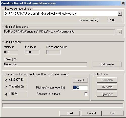
This mode allows to construct a flood zone by the specified point of lifting a water level. The specified point should be provided by data of a matrix of heights of a relief (MTW) that are set in group the Source surface of relief. Coordinates of the specified point are displayed in group the Checkpoint for construction of flood inundation areas.
Dialog of construction of flood zone at this point:
Result of construction is the matrix of qualities (MTQ), containing values of depths of flood zone. The element's size of a resulting matrix of depths in meters on the ground is defined by the element size of an initial matrix of heights (MTW). If the mode the Absolute level mark is not set, then at constructing a zone of flooding, the user-defined relative level rise of water is added to the coordinate H of the specified point received from a matrix of heights. Heights of a relief of construction's area are subtracted from the received value of a water's level and differences are recorded into a matrix of depths. If the mode the Absolute level mark is set, then the value of field Rising of water level (m) is used as a water's level. For customizing a legend of depths matrix the button is used Set palette, its which pressing opens the dialog for setting a palette of a matrix of qualities. At setting a legend of a matrix of depths it is possible to set the minimum and maximum displayed value, quantity of diapasons of depths and a color palette. The palette of a created matrix of depths can be loaded from the file of previously created matrix. Ranges of depths can be non-regular, color of the last diapason can be used for display of values greater than the maximum, that gives to the user flexible means of setting a legend of a resulting matrix of depths. |