Construction of flood zone by depths points |


|
|
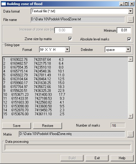
Watermarks contain the coordinates of point X, Y and relative height of the water level at this point. Coordinates of marks and value of a water level are set in meters in the coordinate system of a vector map. Waterlevel marks should be provided by data of a matrix of heights of a relief (MTW). The marks which are not provided by data of a matrix of heights, are excluded from processing. Values of level can be set by sizes of exceeding concerning a surface of relief (the mode Absolute level marks is not set) or by values of absolute heights of level (the mode Absolute level marks is set).
Dialog of Construction of flood zone by depths points:
Result of construction is the matrix of qualities (MTQ), containing values of depths of a flood zone. According to data of level marks the water surface is constructed which one then compares with a surface of area relief. If the water surface in the terrain point is located above a relief's surface, then into a resulting matrix of qualities the value of depth of flooding in the given point is written. Water level marks can be set: - in a textual file; - in the database table; - by selected point objects of a map. If level marks are contained in a textual file (Data format - textual file), then to one mark there corresponds one string of a text file. The format of a string ("X Y H", "№ X Y H") and a delimiter of fields can be set in group the String type. If level marks are contained in a database (Data format - the Data base), then at a DBF-file choice it is necessary to make set-up of conformity of coordinates of marks and database fields in dialog the Selecting of fields from data base. If level marks are presented by marked dot objects of a map (Data format - Selected objects), then the metrics of these objects should contain H coordinate (value of a water level) and a sign of Height relative to a surface. Preset marks of a water level are displayed in a dialog window. If the marks are contained in a textual file or in a database, then the coordinates of the marks and the level value can be edited. Values of level can be set by sizes of exceeding concerning a surface of relief (the mode Absolute level marks is not set) or by values of absolute heights of level (the mode Absolute level marks is set). The size of the terrain area for which the flood zone is built, are defined by the coordinates of the specified marks. If you want to extend the flood zone area, you need to set the value in window Increase of zone size. In the window the Minimum depth it is possible to set the lower threshold value of depths of a zone of flooding. For example, if a user is interested in depths of more than one meter, then he should set in the window the Minimum depth the value "1.0". Then the depths of less than one meter in the resulting matrix of qualities will not be recorded. |