Adjustment of polygonometry course of any form by method of the least squares |


|
|
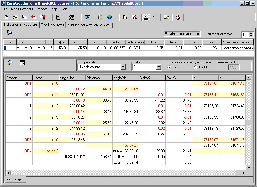
At adjustment of polygonometry course the errors of initial data are ignored. It is recommended to solve the task as follows: - After starting for performance of the task geodetic calculation the dialog box appears Geodesy calculations. - By selecting the appropriate menu item Polygonometry traverse or click the button in the Quick Launch toolbar, the task will run. - After opening the dialogue Construction of a theodolitic course it is needed to set some parameters in the tab Polygonometry courses.
Input of several theodolitic courses is stipulated for this program. The quantity of theodolitic courses is specified in a window of editing (the right top corner of dialogue, above the table of courses characteristics). By change of Courses field value it is possible to add new pages (for data input onto a following course) or to delete pages (deleting occurs by a method “the last has come - the first has left”). Further it is necessary to set: 1. Quantity of stations (above the table of data). 2. Type of a course (unlock, close, lock, etc.). 3. The measured corners on a course (left or right). 4. Prefix of a course point.
Having set the information in a window of editing Prefix of a point, we shall receive names of points of the course, beginning from this prefix and a serial number. For example, "prefix" = “ т.х. ”, formed names of points = т.х.1, т.х.2, etc. Initial data are entered into the table of data or manually (example), or from earlier created file of initial data (Open item in the File menu or the Open button in panel of tools; the name of the open file of TEO format will be placed into heading of dialogue). If necessary entered data may be corrected (it is important: upon termination of correcting a cell of the table it is necessary to click Enter). Also source data it is possible to receive and enter by automatic loading from the corresponding files of digital geodetic devices, using library “GeoLoad.dll” (Import item of File menu or Import toolbar button). After input of source data for construction of a theodolitic course they can be saved in a file of TEO format for their repeated use in the further (Save item in File menu or Save toolbar button; the name of the saved file will be placed into heading of dialogue). To save it is possible both data from the current page, and data from all pages into one file under one name. Before the beginning of balancing it is necessary to be sure that the received field material of good quality, for this perform preliminary calculations by nonstrict, separate method when angles at first are equalized, and then separately among themselves increments of coordinates. (Click the button Adjustment of the traverse/nonstrict, separate adjustment of the course on the panel of tools or item Calculate course/Nonstrict, separate adjustment of the course in the Measurement menu.) Nonstrict separate method of adjustment is applied in polygonal courses 1 and 2 categories, and also to calculation of working coordinates. The purpose of preliminary calculations in a polygonometry - definition of quality of field measurements and their conformity by accuracy to requirements of the instruction, as well as preparation of the measurement's results for the equalization calculations. As a result of preliminary calculations determine discrepancies of courses and compare to their limiting values. Formulas for calculation of discrepancies: а) Angular discrepancy
б) Linear discrepancy
Admissions are set in Adjustment of parameters for report and can be changed. In case of a deviation from admissions, result of measurements are highlighted by red color. Strict adjustment by correlated way is made under a condition of a minimum of the sum of products of squares of amendments into all measured in the course the sizes onto their weights, i.e. [pv2] = min.. (Click the button Adjustment of the traverse/strict adjustment korrelatnym way of tools panel or item Calculate course/strict adjustment korrelatnym way in the Measurement menu.) Adjustment is made with obviously specified mean-square mistakes of linear and angular measurements: mβ - is taken, as a mistake of measurement of angle (Fang), set in adjustment of the parameters, divided on 2; ms - s.k.p. of measurement of distance is calculated by the formula ms = 15+3*Sср;
Adjustment of polygonal courses with several central points is carried out by a method of successive approximations (item of menu Measurement\Calculate the system moves\Approximation method). The received results can be saved in the form of the sheet (Report menu or the Report in Microsoft Word toolbar button). Thus, results of calculations can be seen at first in Word, and in the further this sheet can be saved or printed out by means of Word. For creation of such sheet it is necessary that there was template for the report. Template: "theodol.dot" is necessary for the given task. It is possible to plot onto user map the constructed course (Map menu or To plot objects toolbar button). Data both from current page and from all pages at once are plotted. After you plot objects onto a map it is possible to return a map into a status which was before plotting. For this purpose in Map Editor task to execute Undo item. Upon termination of processing the entered source data the table can be cleaned (Clear the data of current calculation sheet button of a toolbar or of the like item in Measurement menu) and to process new data or to close dialogue. Coordinates and names of the received points will be stored in memory up to the closing the basic dialog box "Execution of geodesy calculations" and can be used in tasks: Solution of direct geodetic tasks, Return geodetic task and Setting operations. If points with identical names participated in calculations the coordinates of points calculated by last will be saved. At closing of Construction of a theodolitic course dialogue in case new data have not been saved before on a hard disk and the attribute Autosaving of calculated files is not set, the message will appear: Save data in the project?. The positive answer - creates a file of a theodolitic course on a hard disk with a name of a file of the given project, but with ".teo" extension and registers it in the project.
|