Building a hexagonal grid |


|
|
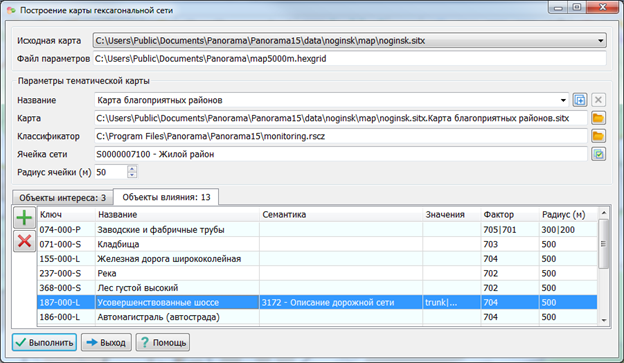
The dialog is intended for entering, editing parameters, and constructing a hexagonal network. The name of the parameter file is automatically determined by the name of the original map classifier. The user can save parameters under different names. By default, parameters for the Favorable Areas Map classifier are prepared. The selection of a network cell is performed in the hexagonal network classifier.
Setting parameters when changing the hexagonal network classifier:
1. When switching to a new classifier, perform the following actions: 1.1. Check for the presence of an object to create network cells in the new classifier; 1.2. If the object is absent, select an alternative type of object from the prepared classifier.
2. Sequence for setting parameters: 2.1. Set the radius of the hexagonal network; 2.2. Configure parameters for objects of interest; 2.3. Specify parameters for influence objects.
Note: The new classifier must be prepared in advance for the correct construction of the hexagonal network.
The cell radius corresponds to the radius of the circumscribed circle of the hexagon. Reducing the radius value increases the time required to construct the hexagonal network.
Objects of interest are the entities for which hexagonal objects containing statistical data are created. Influence objects are those that define positive and negative influencing factors on neighboring objects of interest. When selecting objects based on semantics, it is necessary to choose the semantics and the semantic values of the selected objects from the original map. The classifier of the original map (map5000m.rscz) contains descriptions of the objects of interest and the influence objects.
The Factor column contains the codes of the influence semantics, selected from the hexagonal network classifier (monitoring.rscz). The Radius (m) column contains the influence radii of the selected factors. The configuration of parameters for objects of interest and influence objects is performed in separate dialogs, which open upon double-clicking with the left mouse button.
The construction parameters are contained in a parameter file with the extension hexgrid. Parameter files contain references to object keys and characteristics of the original map used for building the thematic map.
The name of the parameter file corresponds to the name of the classifier of the original map: c:\Users\Public\Documents\Panorama\map5000m.hexgrid |

