Export of matrix of heights into TIFF and KMZ file |


|
|
The generated GeoTIFF file contains projection parameters and coordinate systems of the source DEM. The parameters of the vertical coordinate system created in accordance with the height system of the original matrix are also written to the output file. A GeoTIFF file for a vertical coordinate system stores the name of the vertical coordinate system, the height units contained in the file, and other parameters. Currently, data is entered into the GeoTIFF file for such systems of heights as: • «Baltic 1977 height (EPSG:5705)»; • «WGS 84 (geographic 3D) (EPSG :4327)»; • «MSL height (EPSG:5714)».
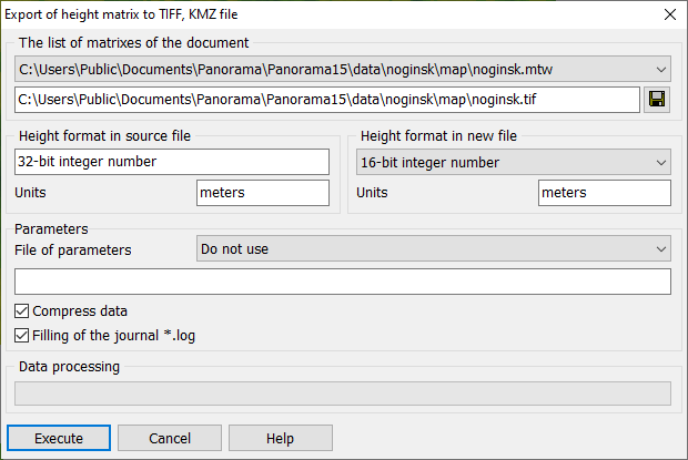
The source matrixes in MTW format files can contain heights in the following units: meters, decimeters, centimeters, millimeters. The matrix element can be written in the following formats: an integer of size 8 (BYTE), 16 (INT16), 32 (INT32) bits, a real number of 64 bits (FLOAT64). When constructing a matrix of heights based on vector map data in GIS Panorama, the height values are recorded in the format of an integer with a size of 32 bits with a precision of 1 millimeter in height. Matrixes loaded from other formats can have a format from 8 to 64 bits with a precision of 1 millimeter to 1 meter. The application Summ elevation matrixes allows to reduce precision of values of height to decimeters, centimeters or meters. Reducing the precision allows you to reduce the size of the matrix in compressed form. The dialog shows the height format and units of measurement in the source matrix of heights. Based on this data, when saving the matrix into a TIFF file, the user can select the height format in the new file: BYTE, INT16, INT32, FLOAT32, FLOAT64. If the source height units are «decimeters», «centimeters», «millimeters», then for saving the heights into TIFF without loss, it is recommended to choose the format 32 bits in real numbers (FLOAT32). When selecting INT16 and INT32 formats, the height values are rounded to whole meters (round up). If the source height units are «meters», then it is recommended to save in 16-bit format. If you select the «Compress data» option, the TIFF file size will be minimal. The BYTE format selection is available only if the source matrix is in BYTE format. The FLOAT64 format selection is available only if the source matrix has the FLOAT64 format. Control's element «To cut an image on a border» is accessible at export of matrixes of the heights limited by a border. Control's element «To cut an image on a border» is intended for filling the area outside the frame of a matrix, by the value «no data». Value «no data» is stored in the tag GDAL_NODATA of TIFF file (tag code 42113). Control's element «Filling of the journal*.log» is intended to enable the mode of conducting the transactions log, in which the abnormal situations arising at import of a matrix of heights into TIFF file are recorded. The saved KMZ file is an archive of the KML file with a set of single-band GeoTIFF files with elevation data. The KML file contains a description of the data - the filenames with the coordinates of a binding the matrixes of heights, and also the priority of their drawing.
The mode is launched on the «Matrixes» bookmark of the «Data List» dialog box by the «Save as ... - TIFF, KMZ» context menu item.
|