Automatic sattelite recognition |


|
|
The Automatic Image Recognition task is designed for the automatic recognition and vectorization of data on satellite imagery, aerial photographs, and UAV data. The application sends a request to the "Panorama Vision" automatic recognition and vectorization service to interpret an image based on a selected area or object. Available recognition includes contours of agricultural fields, hydrographic objects (rivers, lakes, seas, ponds), forestry objects (mature forest, young growth, clearings), buildings and structures, and paved/unpaved roads.
The Forest recognition mode identifies objects of three categories on images: mature (high-stem) forest, young forest growth (young tree plantations, shrubs), and clearings (areas with recently removed tree stands).
The Urban recognition mode performs joint interpretation of road networks and buildings on images. This mode recognizes paved and unpaved roads on images and also allows classifying buildings into several subtypes: residential buildings (multi-story and individual residential buildings), public buildings (schools, kindergartens, hospitals, etc.), industrial and commercial buildings (factories, shopping centers, etc.), and garages (garage-building cooperatives). Buildings recognized in Urban mode are oriented along the direction of the nearest roads.
Complex processing allows you to create vector maps from images using a single request, generating a whole set of objects: agricultural fields (arable land), water bodies (rivers, lakes, and others), forests (high-stem forest, young growth, clear-cuts), buildings, and roads. As in the "Urban" recognition mode, the service not only finds buildings but also identifies their subtype. To enhance the accuracy, the final vector boundaries of the generated polygonal objects (forests, arable land, water bodies, buildings) are automatically reconciled with each other.
The service is based on neural network analysis of high and very high-resolution multispectral satellite imagery. The task can process terrain images in RSW/JPG/TIFF/PNG formats. Source images can be user data with a resolution of 10 meters/pixel or better, or open data sources – geoportals. This task is available to all users of Professional GIS Panorama 15 who have purchased the module for access to the "Panorama Vision" automatic recognition and vectorization complex.
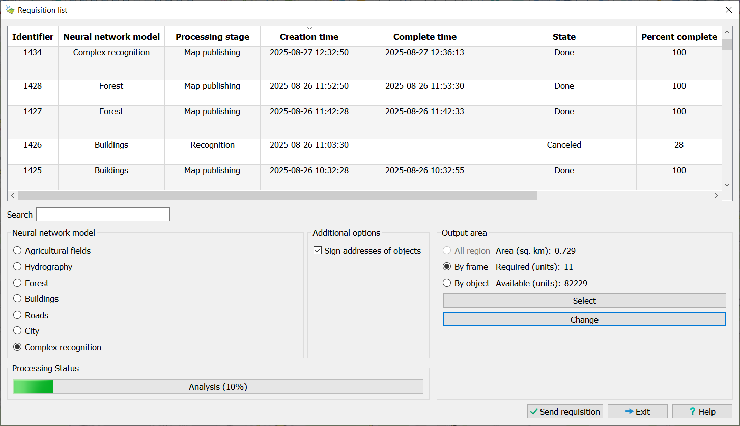
The dialog of the mode consists of a page for managing data recognition settings. The user can choose one of the recognition models. Data sources can be user rasters (terrain images), an open geoportal, or a combination of data. The output area can be limited by open data, by an object, or by a rectangular area. To do this, click the Select button after choosing one of the area selection modes. The dimensions of the selected area can be adjusted by clicking the Modify button.
When recognizing using user images, they will be uploaded to the server. To start the processing process: 1. Open raster images (terrain imagery) in GIS Panorama and/or connect geoportals with satellite imagery. 2. Select the area of interest in the "Panorama Vision" complex dialog. 3. Click the Submit Request button.
During processing, the user receives information about all their requests. This information includes the request number, neural network model, request creation time, processing stage, overall completion percentage, completion time, and the ID of the ready vector map. For convenient data navigation, a search function is built into the dialog. Search is performed across any field in the table. To search, simply enter the relevant information in the Search field.
When recognizing in the Buildings, Roads, Urban, and Complex Processing modes, the service automatically identifies the addresses of buildings and streets detected in the images. Based on integration with the "Panorama" GIS address database for the territory of the Russian Federation (address.gisserver.info), the service populates the following object semantics: For buildings: "House Number" (31202), "Street Name" (31201), "Settlement Name" (3106), "City Name" (31207), "District Name" (3108). For streets and highways: "Proper Name" (9), "Settlement Name" (3106), "City Name" (31207), "District Name" (3108).
Additionally, when generating a vector map of the area, objects with populated address semantics are automatically labeled. House numbers and street names are displayed on the map.
When using the service, the total volume of processed data is limited by the number of purchased processing units (p.u.). The cost of interpreting 1 km² depends on the selected neural network model and is indicated on the product page. The available area can be increased by purchasing additional processing rights. Information about the area of the selected area of interest, the number of required and available processing units is displayed in the dialog in the Output Area parameter group. If processing the selected area requires more processing units than are available to the user (or more than 1000 p.u.), the frame around the area is highlighted in red on the map. If the user has exhausted the limit of purchased processing units, they will be limited to no more than two requests per day with a limit of 25 processing units.
To interrupt the processing process, select the request in the list, right-click, and select Cancel Request from the context menu.
To open the finished vector map, double-click the left mouse button next to a request with the status Completed, or right-click and select Open Layer from the context menu. When opened, the map is automatically added to the list of available User Layers in the Geoportals list for further use. The map is loaded via the WFS protocol. The user can copy and edit the received map, as well as convert it to other formats.
When creating the vector map, objects are formed using the unified classifier map5000m.rscz. • Agricultural land objects are formed using the "Agricultural land" object with code 71324000. • Hydrography objects use the "Water body" object with code 31120002. • Mature forest is mapped as area objects "Dense tall forest" with code 71111110. • Young forest growth is mapped as area objects "Young forest growth" with code 71113000. • Clearings are mapped as area objects "Clearcut forest" with code 71112300. • Paved roads are mapped as linear objects "Highway" with code 61230000. • Unpaved roads are mapped as linear objects "Street" with code 45200000.
Buildings are mapped as area objects of the following types: "Residential building" (with key "a_residential_b"), "Public building" (with key "a_public_b"), "Industrial enterprise" (with key "a_industrial_b"), "Garages (GSC and others)" (with key "a_garages_b"). The position of all buildings on the map is adjusted to align with their foundations.
During operation, the user may receive error messages: • User authorization error on the server – the user lacks a protection key or the server is temporarily unavailable. • Processing error – occurs if the server could not process the selected area. To clarify the reason, contact technical support. To do this, enable diagnostic logging, repeat the error, and send the generated log file located at c:\ProgramData\panorama64.*computername*.log to the email address panorama@gisinfo.ru. • Projection parameters are not set in the selected rasters – the rasters for recognition do not support geodetic recalculations; it is necessary to set the raster projection parameters.
Demo Mode
If user limits are exceeded or if a license for Panorama Vision is absent, working with the service is only available in demo mode. In demo mode, the user can send no more than one request per day, with a total area according to the table below.
| ||||||||||||||||||||||||