Vector objects offset |


|
|
This mode is intended for displacement of vector and point signs (buildings), and also the labels relative to contours of linear and area objects (roads) with deleting of intersecting signs. At deletion the calculation of degree of symbol importance is carried out. The structures located near to intersections of roads have the maximum degree of importance. Structures located near to contours of roads have average degree of importance. Structures, located away from the contours of roads (inside quarters) have the minimum degree of importance.
Parameters of processing: — Minimum distance to a contour defines distance between a vector symbol and analyzed contours of roads. Recommended value — 0.1 mm on a map. — The minimum distance between marks defines the distance between vector symbols (for example, between structures). Recommended value — 0.2 mm on a map.
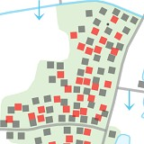
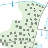
During processing, into the vector signs intended for deletion there is added a service semantic characteristic — 31002 Color of object (RGB) (value: 255 — red color) also the object's visibility limitation is set (the top border of scale of display is lowered onto one position below the base scale). The obtained data should be assessed visually. If you want to save the selected symbol, you should delete the semantics 31002 and set the visibility limits of the object "By default". If you need to delete the selected symbols, you should select objects by the condition of having the semantics 31002 and delete the selected objects.
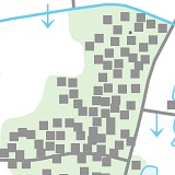
Structures on the source map (1), after processing (2), after deleting of structures (3)
|


