Creating flood zone along the fairway |


|
|
Linear features must include water level values pre-flooding as a third coordinate. If the third coordinate is not specified, it will be derived from elevation matrices. Point objects should contain flood level values in the specified semantics and be located at nodes of linear hydrographic features or in close proximity to them.
For area-based hydrographic features such as rivers, linear fairway objects must be manually delineated for processing.
Input data: — Vector map with fairways and flood level marks; — Height matrices.
Output data: — Quality matrix containing flood depths.
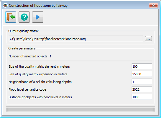
Dialogue Construction of flood zone along the fairway Main panel contains 3 buttons:
On the Output quality matrix panel you can change the name of the output quality matrix.
The Construction parameters panel contains an indicator showing the number of selected objects. Only linear objects with three-dimensional metrics are processed; other selected objects will not be processed.
In addition, the panel contains the following customizable parameters: — Size of the quality matrix element in meters. By default, the size of the smallest element of height matrices is taken. If the flood zone was constructed incorrectly, you can increase the element size to correct the error. — Size of quality matrix expansion in meters. The amount by which a rectangular frame covering the selected objects will be extended in all directions. — Neighborhood of a cell for calculating depth. The value responsible for the degree of depth averaging when calculating the flood level value in each cell. In most cases, a value of 1 is sufficient. If the flood zone was constructed incorrectly, the value can be increased up to 5 to correct the error. — Flood level semantics code. The semantics code of point objects containing the relative value of the flood level. — Distance of objects with flood levels in meters. Maximum distance of point objects with flood levels from nodes of linear hydrographic features. If this parameter is set to 0, only point objects located at nodes of linear features will be considered.
Procedure: 1. Open a map containing linear hydrographic features and point objects with flood levels. 2. Add elevation matrices to the document for the same area. 3. Select the linear hydrographic features on the map. You can choose one or multiple objects. 4. Open the panel 5. Click on the button |