Construction of engineering-geological profiles in the form of the scheme |


|
|
Order of the task execution: - by means of the map editor to create linear object «GEOLOGICAL CUT»; - during digitizing a line of a profile (cut) it is necessary to use auxiliary modes of creation «K»-capture of an another's vertex (take vertex) and/or «I» a-copy of a vertex of the chosen object; - to choose on the panel of buttons a mode «Construction of engineering-geological profiles in the form of the scheme»; - to specify on a map a linear object «GEOLOGICAL CUT»; - to enter parameters of construction of a profile in dialog «Creation of the scheme of a profile»; - to open a map containing the drawing of the scheme of a profile; - to execute editing the scheme of a profile by means of the map editor.
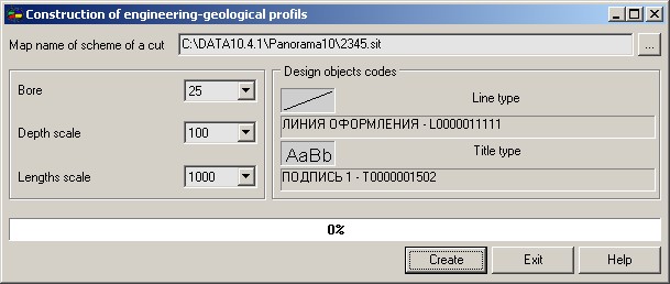
In dialog of a mode it is necessary to specify parameters of construction of the drawing: - to set a map name of the drawing of the scheme of an engineering-geological profile; - to enter a scale of depths (scale on a vertical axis of the drawing); - to enter a scale of lengths (scale on a horizontal axis of the drawing); - to specify codes of design objects.
Received drawing of an engineering-geological profile is a schematic drawing. Factually it is a set of the engineering-geological columns which have been stretched on all length of a profile in view of boreholes location. The given scheme is the initial information for formation of an engineering-geological profile. Editing of the scheme (merge of objects, interpolation of the metrics and so forth) is carried out by means of the map editor.
To improve the visualization of the scheme and facilitate its editing, you can use models of a relief. If there is an open model of a relief (matrix of heights, matrix of layers, TIN model, point cloud), the creation of a scheme is carried out taking into account the heights of the relief. The ground surface line and borehole layers are put onto the scheme in accordance with the heights requested along the line of geological cut with a given step. In the absence of the model of a relief, the layers of wells are put onto the scheme using rectangular objects.
|