To sign length of a piece (with dimensional line) |


|
|
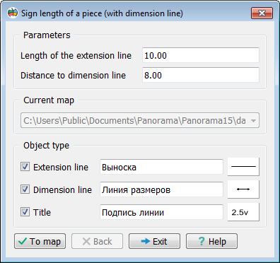
The dialogue window of this mode has the following appearance In the top part of dialogue two fields that need to be filled are located. If any of these fields remain empty, then To map button will be inactive. In the Length of the extension line field itself the length of these lines in mm on the map is indicated. In the Distance to dimension line field the distance from the piece of the object metric to the dimension line in mm on the map is indicated. Below these fields a drop-down list of open maps is located, in which you can select a map for editing.
In the Object type section there are elements for customizing the type of objects and attributes, which of them should be put on the map. The values of these fields are assigned by default in the dialog Parameters of geodesy editor. For the extension line, the default value is located in the Scheme bookmark, in the Appearance of the scheme section, the Line of appearance element. For a dimension line - in the Editor bookmark, the Line element. For titles - in the Editor bookmark, the Title element.
In the bottom part of dialog four buttons are located. To map button is intended for starting the procedure for calculating the length of pieces of the object metric and forming the signatures. Back button cancels last procedure of drawing the information on the map. It becomes active only after the successful execution of signing the sizes on the map. Exit button is designed to stop working with the dialog. Help button calls the help information on the screen.
|