Download zoning maps for object |


|
|
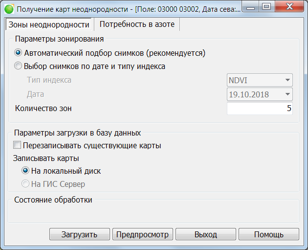
Dialog «Download zoning maps for object»:
The dialog consists of tabs for selecting the type of maps to be obtained and elements for setting up loading into the database. The resulting maps can be used in systems for differentiated fertilization. There are two types of maps available for obtaining - Zones of heterogeneity and Nitrogen demand. Maps of zones of heterogeneity consist of a specified number of areas similar in characteristics based on several automatically selected images among the last available during the growing season and with open soil according to the vegetation index NDVI or with a choice of a specific type of index and the date of the image. Indices NDVI, EVI, CVI, GNDVI are available for selection. The number of zones can be set from 2 to 25 inclusive. Maps are loaded in sitx format. Nitrogen demand maps are generated using one of two methods for calculating fertilizer demand based on the original NDVI image date and application rates. In the maximization method, higher doses of fertilizer are applied to zones with a high value of the vegetation index and lower doses to zones with a low level of index, which allows to increase the return on the most developed areas. When choosing a leveling method, areas with a high NDVI level receive lower doses of fertilizer, and areas with high value of an index the higher doses, which allows to level out the development of the crop in the working area. The snapshot date determines the NDVI snapshot from which the map will be built. Doses selection elements are used to set the planned application dose, the minimum and maximum values that it can take. The section of parameters for loading into the database allows you to select a place for placing maps (data directory on a local disk or GIS Server) and configure skipping or rewriting of maps if a similar record is already contained in the database. At the bottom of the dialog there are buttons for loading maps, opening a preview raster in the main map window using the current parameters, closing the form and opening the mode help. |