Download of vegetation index matrixes for object |


|
|
Dialog «Download of vegetation index matrixes for object»:
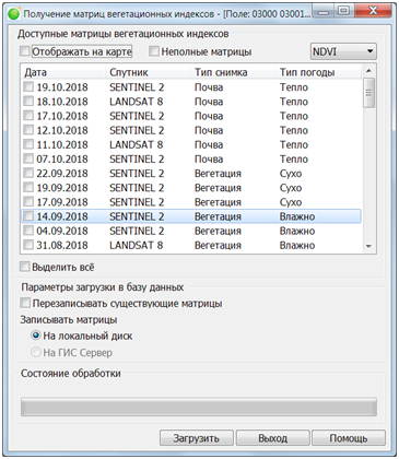
Dialog consists of the table of available matrixes onto current object and controls for a loading mode. The choice of the type of vegetation index is performed using the drop-down list. Available indices: Normalized Difference Vegetation Index (NDVI), Chlorophyll Vegetation Index (CVI), Enhanced Vegetation Index (EVI), Green Normalized Difference Vegetation Index (GNDVI). The numerical values of vegetation indices are calculated by an external service using multispectral images. The result is presented in the form of a matrix of qualities with discreteness corresponding to the resolution of the original image. The list of available matrices displays the date of shooting, the type of the image and the type of weather. In type of image on the basis of value of vegetation indexes there is supposed a presence of vegetation (type «Vegetation») or its absence (type «Soil»). For images with vegetation, wet or dry weather is indicated, for images with soil, an estimate is given for warm or cold temperatures. In the mode Incomplete matrixes into the table there are added the matrixes containing gaps in the data by reason of hitting of initial object onto border of a satellite image or the area covered by clouds. When the Show on map mode is used, a selecting any matrix from the list will add it onto the map in the main window as a raster. In this mode rasters are displayed with a dynamic palette. For each image, the correspondence between the values of index and palette colors is calculated separately. Dynamic palettes allow assessing the heterogeneity of the distribution of the vegetation index's values within the boundaries of the field contour, but are not suitable for comparative analysis of indicators for different dates. Switching on the static palette is possible with the help of the corresponding item of the «Satellite farming settings» dialog, but only for the NDVI and GNDVI indices.
Mode of a pre-browse of matrixes in the main window:
Saving onto GIS Server is available only if there is an active connection in the main Panorama window. Loading of matrixes is carried out into the directory the Folders of data on a disk or Folders on the GIS Server from the Parameters dialog of the Field passport task. The description of the loaded matrixes is added into a database for the further browsing through the Browse remote sensing products dialog. To support collective work or, if necessary, analysis of the matrices of vegetation indices in the web application, the requested data should be saved onto the GIS Server. |