Hydrography Objects and Elevation Matrices Alignment Tool |


|
|
The Hydrography Objects and Elevation Matrices Alignment Tool is designed to generate elevations at nodes of hydrography objects taking into account flow directions based on elevation matrices with subsequent correction of the matrices.
Objects with the following codes are processed in the configuration file located at C:.xml. In this file, objects are divided into three groups for each classifier:
— Linear hydrography objects (hydroLine). — Area hydrography objects with constant water level (hydroConst). — Area hydrography objects with variable water level (hydroDiff).
Example of object descriptions in the map5000m.rcsz classifier file in the hydrolay.xml file:
<config> <classifier name="map5000m.rcsz"> <hydroLine> <code>31431000</code> <code>31410000</code> </hydroLine> <hydroConst> <code>31110000</code> <code>31120000</code> <code>31133000</code> </hydroConst> <hydroDiff> <code>31410000</code> </hydroDiff> </classifier> </config>
If necessary, data for other classifiers is added to this file in a similar manner.
Input data: — Vector map with hydrography objects. — Elevation matrices.
Output data: — Vector map with calculated heights for objects. — Elevation matrices with adjusted heights.
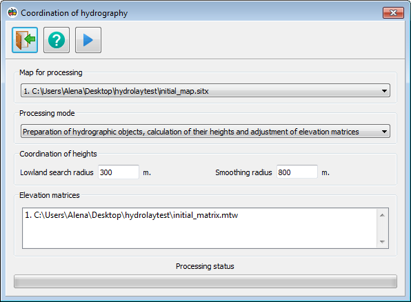
Coordination of hydrography dialog
1. Main panel. The main panel contains 3 buttons:
2. Map for processing. A dropdown list with all open cards. Only objects from the selected card will be processed.
3. Processing Mode. A dropdown list with processing modes. Modes include one or more stages of data processing:
— Preparation of hydrographic objects. At this stage, hydrography objects are harmonized with each other: intersecting objects are separated, identical objects are merged.
— Calculations of their heights. At this stage, heights from elevation matrices are transferred to hydrography objects, after which these heights are adjusted. Linear hydrography objects should have a smooth decrease in height from the first point to the last, and heights are adjusted based on the object's direction. If the last point of a linear hydrography object is higher than the first, the height from the first point is transferred to the last point, and then heights are recalculated in adjacent objects. For area hydrography objects with constant height, there should be one height at all points, calculated as the arithmetic average of elevation matrices within the object. For area hydrography objects with variable height, the height at points depends on the elevations in elevation matrices and the heights of adjacent hydrography objects.
— Adjustment of elevation matrices. At this stage, heights from hydrography objects are transferred to elevation matrices. Heights near hydrography objects are smoothed if a smoothing radius is specified.
4. Coordination of heights. This panel contains 2 parameters:
— Lowland search radius – the radius within which the minimum height is searched for each point of an object. If a vector river object does not fall within the riverbed in the elevation matrix, the program will search for the riverbed within the specified radius.
— Smoothing radius – the radius within which values of elevation matrix elements near hydrography objects are recalculated.
5. Elevation matrices. List of elevation matrices to be processed. |