Automatic sattelite recognition |


|
|
The task Automatic sattelite recognition is designed for automatic recognition and vectorization of data on satellite images, aerial photographs, and UAV data. The application sends a request for decoding the image of a selected area or object to the "Panorama Vision" automatic recognition and vectorization service. In the first stage, contour recognition of fields, rivers, lakes, seas, and ponds is available. Contour recognition for agricultural fields, hydrological objects (rivers, lakes, seas, ponds), buildings, and structures is now available.
The service operates based on neural network analysis of high and very high-resolution multispectral satellite images. The task allows processing terrain images in RSW/JPG/TIFF/PNG formats. User data with a resolution of 10m/p or better, or open data sources such as geospatial portals, can be used as image sources. All users of Professional GIS Panorama 15 who have purchased the module for access to the complex of automatic recognition and vectorization "Panorama Vision" can take advantage of this task.
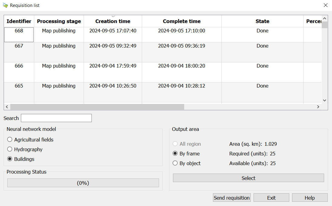
The dialogue mode consists of a data recognition settings management page. It is possible to select one of the models for recognition. The data source can be user rasters (images), an open geospatial portal, or a combination of data. The output area can be limited based on open data, by object, or by a rectangular area. To do this, click the Select button, setting one of the area selection modes. When recognizing user images, they will be preloaded onto the server.
To start the processing process: 1. Open raster images (aerial photographs) in GIS "Panorama" and/or connect to geoportals with satellite images. 2. Select an area. 3. Click on the Send requisition button.
During the processing process, the user is provided with information about all their requests. This information includes the application creation time, processing stage, overall completion percentage, completion time, and the identifier of the finished vector map. During recognition, the user is provided with information about the request status, completion time, processing stage, completion time, and readiness. For ease of navigation through the data, a search function is integrated into the dialogue. Search can be conducted on any of the fields in the table. To search for data, simply enter the relevant information in the Search field.
When using the service, the total volume of processed data is limited by the number of purchased processing units. The cost of deciphering 1 km² depends on the chosen neural network model and is specified on the product page. It is possible to increase the available area by purchasing additional processing rights. Information about the area of the selected region of interest, the number of required and available processing units is displayed in the dialog box in the Output Area parameter group. If a user has exhausted the limit of purchased processing units, they will be able to process no more than two requests per day with a limit of 25 processing units.
To interrupt the processing, select the application from the list, right-click, and choose Cancel Application from the context menu.
To open a completed vector map, simply double-click the left mouse button next to the application with the status Completed, or right-click and select Open Layer from the context menu. When opening the map, it automatically appears in the list of available User Layers in the Geoportals for further use. The map is loaded via the WFS protocol. The user can copy and edit the obtained map, as well as convert it to other formats.
For forming field outlines, the classifier agro10t.rscz is used, and objects are created with code 79000002 — boundaries of agricultural land. For forming hydrological object outlines, the classifier map10000.rscz is used, and objects are created with code 31410000 — rivers, streams. For forming building outlines, the classifier map5000m.rscz is used, creating objects with keys "a_roof_b" (roof, canopy) and "a_residential_b" (residential building).
As a result of the work, users may receive error messages. • User authorization error on the server — the user lacks a protection key or the server is temporarily unavailable. • Processing error — occurs if the server could not process the selected area. To clarify the reason, please contact technical support. To do this, enable diagnostic logging and repeat the error. The generated log file located at c:\ProgramData\panorama64.computer_name.log should be sent to panorama@gisinfo.ru. • Projection parameters are not set in the selected rasters — rasters for recognition do not support geodetic conversions; raster projection parameters need to be set. |