Request of the map object description |


|
|
There is a possibility to request the map object description (brief help information) in Map 2011 system. It can be made as follows: - activate corresponding digital map; - place cursor over object and press Enter or left mouse button.
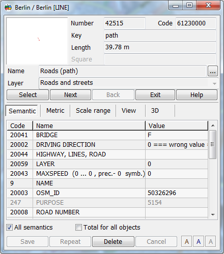
As a result you get a window containing information about selected object.
Since digital map in Map 2011 has multilayer structure, in some cases there are several objects "under" the mouse cursor. By default you see parameters of the "top" object from list. To access list objects use Forward and Back screen buttons. If the object is included into " Set of objects" the information on all objects making this set is displayed in addition. Statistics on objects of a set is displayed only if completely to unwrap a window of the help information on object (Full info mode in pop-up menu). The opened dialog allows viewing and editing semantic, metrics, scale range and displaying style of the object. You can get detailed information about the object by pressing Info button. At overstrike on Info button the detail information ceases to be displayed. The displaying of the object (subobject) metric includes some statistical characteristics, and also coordinate both height of its points and schematic outline displaying. The object metrics related information includes: - number of subobjects; - ID of displaying subobject ( object has number 0); - number of points in object (subobject); - distance between current and following point of object (subobject); - a direction angle or an azimuth from a current to a next point of object (subobject).
The kind of an angle can be set by a choice of the corresponding item of the Pop-up menu. Metrics can be set using different units: - meters in rectangular coordinate systems; - map units in rectangular coordinate system; - pixels in rectangular coordinate system; - radians in geodetic (geographic) coordinate system; - degrees in values range 1E-6 - 1E-7 in geodetic (geographic) coordinate system; - degrees, minutes, seconds in geodetic (geographic) coordinate system.
If you edit object by changing distance and angle, coordinates of vertex that follows current one are changed. You can not correct coordinates of the first object vertex this way. If object metric has 2D coordinates of object elements, is possible to add height to coordinates. For this purpose it is required: - Maximize the window of help information about the object and press Insert H button, or select the appropriate item of the pop-up menu; - Will enter a height value (this value will be set to all points of the object and its subobjects. If height value is not set, the pseudocode of a height is written).
Further by editing it is possible to set different heights in concrete points of the object. To edit height values in object metrics first you have to open Full information window by mouse double click over the dialog title or select Full info from pop-up menu that appears by right mouse click over the dialog. Using popup menu options you can also: - change object vertices numbering (including subobjects); - change vertices numbering for current subobject; - deleting a current subobject; - deleting all subobjects of the object; - Change of accuracy of representation of the object metrics (change of accuracy of displaying of the object metrics actually only for maps with a usual degree of accuracy of coordinates storage at a full-screen variant of representation of the information on object); - establish the selected point of metrics of the closed object (subobject) as the first point.
The general metric description is contained in section the Object metric.
|