Save as |


|
|
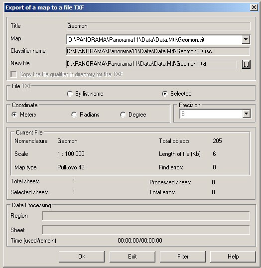
This mode allows to carry out export of a vector map into formats SXF, TXF, DIR. Format SXF is a format of an exchange and storage of vector maps in the archive.
Dialog of export of a vector map:
Format SXF can have the binary form or textual - in the form of TXF file. The text file DIR containing the list of files SXF and TXF can be applied for convenience of import and export at once of several maps (from two up to several thousand). As the map a separate layer, sheet or a set of adjacent sheets with a common passport can be understood. One sheet of a vector map is saved into one file SXF or TXF. The classifier of objects and library of conventional signs (RSC) are not written into file SXF (TXF). Vector map is saved without changing the projection and coordinate system. Sheets of topographical maps are saved with recording coordinates in that zone in which the map sheet is located. Coordinates can be recorded by choice of the user in flat rectangular system of coordinates in meters or in geodetic system of coordinates in degrees or radians. When you save a vector map in text format TXF, it is possible to specify accuracy of stored coordinates (number of decimal places), if coordinates are recorded in meters. Coordinates in radians are recorded with accuracy of 10 digits, in degrees - 8. The user can choose the list of layers and objects which will be saved by using the Filter button. Multisheet map (MAP) or a set of separate maps can be saved into files SXF or TXF with simultaneous formation of file DIR (the list of files SXF and TXF). |