Construction of buffer zone around marked objects |


|
|
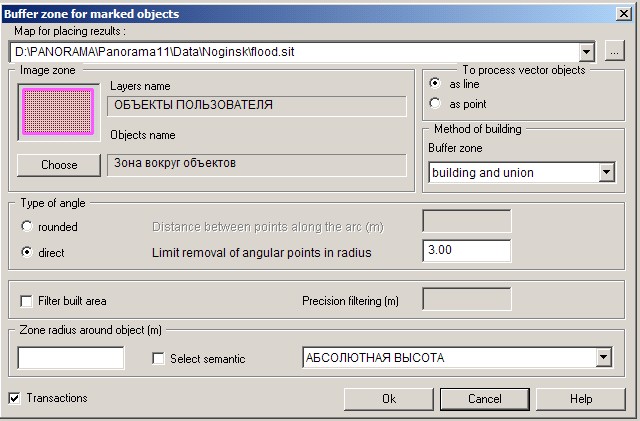
This mode allows to construct a buffer zone around marked objects and to write down it as object into the main or user map. In the task the linear, polygon, point and vector objects are processed.
Dialog «Construction of buffer zone around marked objects»:
For building a zone it is necessary: - by using the dialog of Search/Mark of map objects to set the list of processed objects on the main map or the user map and to press the mode button; - to enter a zone radius in meters or to choose numerical semantics, admissible for marked objects; - for recording objects of a zone to choose an existing map or to create a new one. Result of works is: - creation of a new user map with a file of resources SERVICE.RSC; - into the file of resources of a new map there is added layer the Objects of user; - in this layer the objects the Zone around objects are created with the mandatory semantics Zone radius. At construction of zone by specified semantics the width of a zone will correspond to numerical value of semantics for each object, and into semantics of new object - the Zone Radius - the maximum value of width of a zone is recorded. For construction of zone around vector's objects it is necessary to specify a mode of processing such type of objects - as linear or as point objects. Windows «Distance between points along the arch» and «Limit removal of an angular point in radius» allow users to customize forms of edge of a zone. For the rounded edges of zones the distance between points on an arch in the meters is entered, recommended value - zone radius/15. At direct types of angles it is necessary to specify the maximum distance of a point from the angle in radiuses. Recommended values - from 1 to 3. There is a possibility to change parameters of mode's work. For this purpose in the directory where a current vector map is located, there is a file of initialization of options with INI extension. In this file the section [ZONE] is created, in which it is possible to change a code and the name of objects of a zone, a code and semantics name, a name of a layer and a name of file RSC. |